120 Road to Oregon (1805)
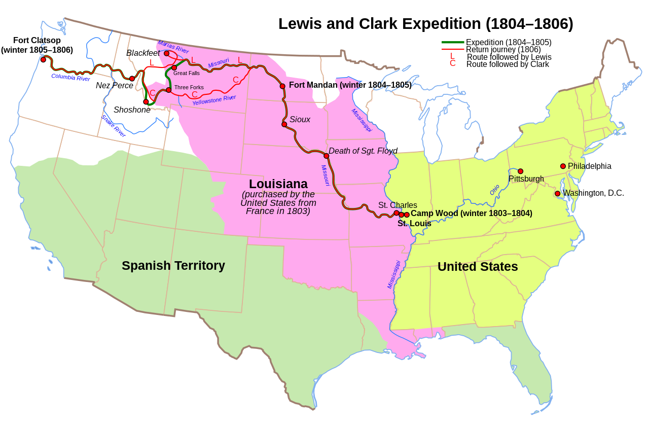
Saturday 27 [July, 1805]. We proceeded on but slowly, the current being still so rapid as to require the utmost exertions of us all to advance and the men are losing their strength fast in consequence of their constant efforts. Here the country suddenly opens into extensive and beautiful meadows and plains, surrounded on every side with distant and lofty mountains. Captain Lewis went up this stream for about half a mile and from the height of a limestone cliff could observe its course about seven miles and the three forks of the Missouri, of which this river is one.
We then left the mouth of the southeast fork, to which in honor of the Secretary of the Treasury we called Gallatin’s river, and at the distance of half a mile reached the confluence of the southwest and middle branch of the Missouri. As we agreed that the direction of the southwest fork gave it a decided preference over the others, we ascended that branch of the river for a mile and encamped in a level handsome plain on the left.
Sunday, July 28. On examining the two streams it became difficult to decide which was the larger or the real Missouri. They are each ninety yards wide and so perfectly similar in character and appearance that they seem to have been formed in the same mold. We were therefore induced to discontinue the name of Missouri and gave to the southwest branch the name of Jefferson in honor of the President of the United States and the projector of the enterprise. And called the middle branch Madison after James Madison Secretary of State.
Tuesday 30. We reloaded our canoes and began to ascend Jefferson river.
Thursday, August 1. Here as had been previously arranged, Captain Lewis left us with Sergeant Gass, Chaboneau, and Drewyer, intending to go on in advance in search of the Shoshonees.
Sunday 4. This morning Captain Lewis arrived at the junction of this river with another which rises from the southwest. He left a note recommending to Captain Clarke the middle fork.
Monday 5. We arrived at the forks about four o’clock but unluckily Captain Lewis’s note had been left on a green pole which the beaver had cut down and carried off with the note, an accident which deprived us of all information as to the character of the two branches of the river. Observing therefore that the northwest fork was most in our direction and contained as much water as the other, we ascended it. We found it extremely rapid and its waters were scattered in such a manner that for a quarter of a mile we were forced to cut a passage through the willow brush that leaned over the little channels and united at the top.
Wednesday 7. We were now completely satisfied that the middle branch was the most navigable and the true continuation of the Jefferson. The northwest fork seems to be the drain of the melting snows of the mountains.
Saturday 10. Captain Lewis continued his route at an early hour through the wide bottom along the left bank of the river. At about five miles he passed a large creek and then fell into an Indian road leading towards the point where the river entered the mountain. This he followed till they reached a handsome open and level valley where the river divided into two nearly equal branches. The mountains over which they passed were not very high but are rugged and continue close to the river side. The river which before it enters the mountain was rapid, rocky, very crooked, much divided by islands, and shallow now becomes more direct in its course as it is hemmed in by the hills and has not so many bends nor islands but becomes more rapid and rocky and continues as shallow. On examining the two branches of the river it was evident that neither of them was navigable further.
Monday 12. This morning Captain Lewis at the distance of four miles from his camp met a large plain Indian road which came into the cove from the northeast and wound along the foot of the mountains to the southwest, approaching obliquely the main stream he had left yesterday. Down this road he now went towards the southwest. At the distance of five miles it crossed a large run or creek which is a principal branch of the main stream into which it falls, just above the high cliffs or gates observed yesterday and which they now saw below them. Here they halted and breakfasted on the last of the deer, keeping a small piece of pork in reserve against accident. They then continued through the low bottom along the main stream near the foot of the mountains on their right.
For the first five miles the valley continues towards the southwest from two to three miles in width. Then the main stream which had received two small branches from the left in the valley, turns abruptly to the west through a narrow bottom between the mountains. The road was still plain and as it led them directly on towards the mountain the stream gradually became smaller till after going two miles it had so greatly diminished in width that one of the men in a fit of enthusiasm, with one foot on each side of the river, thanked God that he had lived to bestride the Missouri. As they went along their hopes of soon seeing the waters of the Columbia arose almost to painful anxiety, when after four miles from the last abrupt turn of the river they reached a small gap formed by the high mountains which recede on each side, leaving room for the Indian road. From the foot of one of the lowest of these mountains which rises with a gentle ascent of about half a mile, issues the remotest water of the Missouri. They had now reached the hidden sources of that river which had never yet been seen by civilized man.
And as they quenched their thirst at the chaste and icy fountain, as they sat down by the brink of that little rivulet which yielded its distant and modest tribute to the parent ocean, they felt themselves rewarded for all their labors and all their difficulties. They left reluctantly this interesting spot and pursuing the Indian road through the interval of the hills, arrived at the top of a ridge from which they saw high mountains partially covered with snow still to the west of them. The ridge on which they stood formed the dividing line between the waters of the Atlantic and Pacific oceans. They followed a descent much steeper than that on the eastern side and at the distance of three quarters of a mile reached a handsome bold creek of cold clear water running to the westward. They stopped to taste for the first time the waters of the Columbia and after a few minutes followed the road across steep hills and low hollows till they reached a spring on the side of a mountain. Here they found a sufficient quantity of dry willow brush for fuel and therefore halted for the night. And having killed nothing in the course of the day supped on their last piece of pork and trusted to fortune for some other food to mix with a little flour and parched meal which was all that now remained of their provisions.
Thursday 7 [November]. The morning was rainy and the fog so thick that we could not see across the river. At a distance of twenty miles from our camp we halted at a village behind two small marshy islands. Opposite to these islands the hills on the left retire and the river widens into a kind of bay crowded with low islands, subject to be overflowed occasionally by the tide. We had not gone far from this village when the fog cleared off and we enjoyed the delightful prospect of the ocean. That ocean the object of all our labors, the reward of all our anxieties. This cheering view exhilarated the spirits of all the party who were still more delighted on hearing the distant roar of the breakers. We went on with great cheerfulness under the high mountainous country which continued along the right bank. The shore was however so bold and rocky that we could not until after going fourteen miles from the last village find any spot fit for an encampment. At that distance, having made during the day thirty-four miles, we spread our mats on the ground and passed the night in the rain.
Source: Meriwether Lewis and William Clark, History of the Expedition under the Command of Captains Lewis and Clark, to the Sources of the Missouri, etc. (Paul Allen, 1814), I, 324 to II, 70. https://archive.org/details/toldcontemporari03hartrich/page/380/mode/2up
