2. Volcano Types and Other Eruption landforms
While not official distinctions, for the sake of easy categorization this textbook will distinguish between volcano types (i.e., overall peaky mountains that erupt) versus other eruption phenomena/landforms that do not necessarily grow mountains but are still composed of lava.
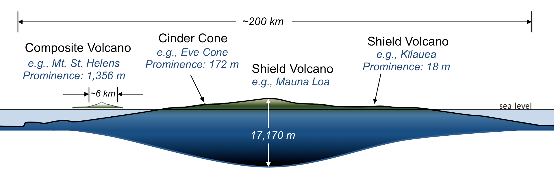
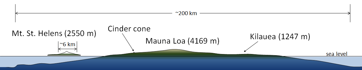
There are three main types of volcanoes, shield volcanoes, composite volcanoes (also called stratovolcanoes), and cinder cones and two other eruptive landforms, lava domes and flood basalts. Which type is created depends on the type of volcanic material being erupted (magma type and whether that creates lava flows, pyroclastic material, etc.) and how it is brought to the surface. Figure 1C.2.1 illustrates the size and shape differences amongst the three main volcano types with shield volcanoes being the largest in volume and area, then stratovolcanoes, then cinder cones as the smallest.
Shield volcanoes, which get their name from their broad rounded shape, are the largest. Figure 1C.2.1 shows the largest of all shield volcanoes—in fact, the largest of all volcanoes on Earth—Mauna Loa, which makes up a substantial part of the Island of Hawai‘i and has a diameter of nearly 200 km. The summit of Mauna Loa is presently 4,169 m above sea level, but this is only a small part of the volcano. It rises from the ocean floor at a depth of approximately 5,000 m. Furthermore, the great mass of the volcano has caused it to sag downward into the mantle by an additional 8,000 m. In total, Mauna Loa is a 17,170 m thick accumulation of rock.
Kilauea Volcano is also a shield volcano, albeit a much flatter one. Kilauea Volcano rises only 18 m above the surrounding terrain and is almost not visible in the scale of the diagram, however it still stretches over a distance of 125 km along the eastern side of the Island of Hawai‘i.
Stratovolcanoes are the next largest. Mt. St. Helens is shown on the left of Figure 1C.2.1. It rises 1,356 m above the surrounding terrain in the Cascade Range of the western United States and has a diameter of approximately 6 km. Stratovolcanoes tend to be no more than 10 km in diameter. Unlike shield volcanoes, stratovolcanoes have a distinctly conical shape, with steep sides.
Cinder cones are the smallest of these three, and almost too small to see next to a volcano like Mauna Loa. Eve Cone is a cinder cone on the flanks of Mt. Edziza in northwestern British Columbia. It rises 172 m above the landscape, and has a diameter of under 500 m. Like stratovolcanoes, cinder cones also have steep sides.
2.1 Volcano Types
Shield Volcanoes
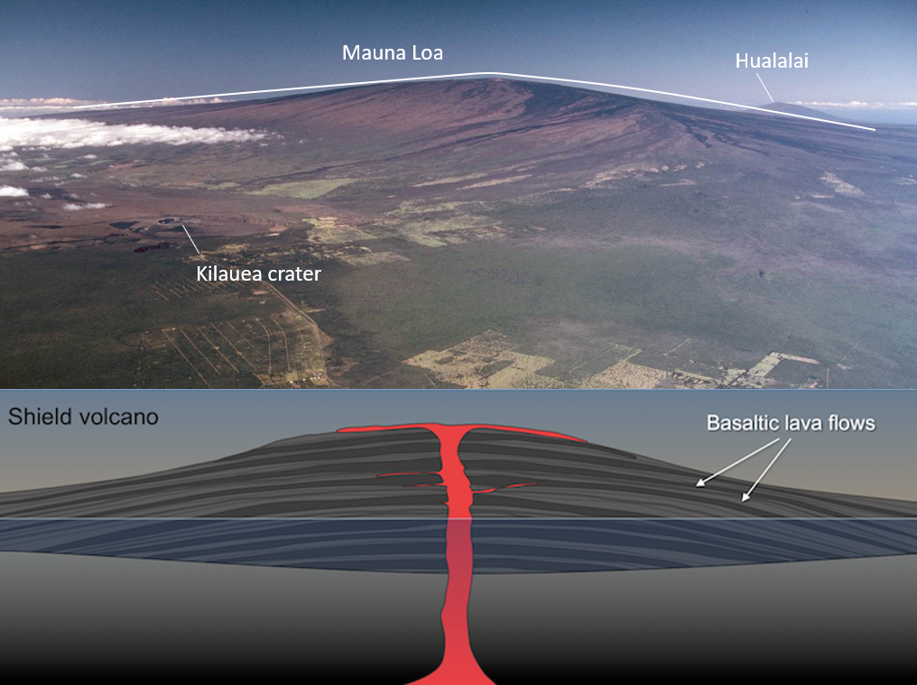
Shield volcanoes, like Mauna Loa on Hawaii (Figure 1C.2.2, top), get their gentle hill-like shape because they are built of successive flows of low-viscosity basaltic lava (Figure 1C.2.2, bottom). The low viscosity of the lava means that it can flow for long distances, resulting in the greater size of shield volcanoes compared to stratovolcanoes or cinder cones. Shield volcanoes have very minimal pyroclastic materials in their structure compared to stratovolcanoes and cinder cones.
Composite Volcanoes (Stratovolcanoes)
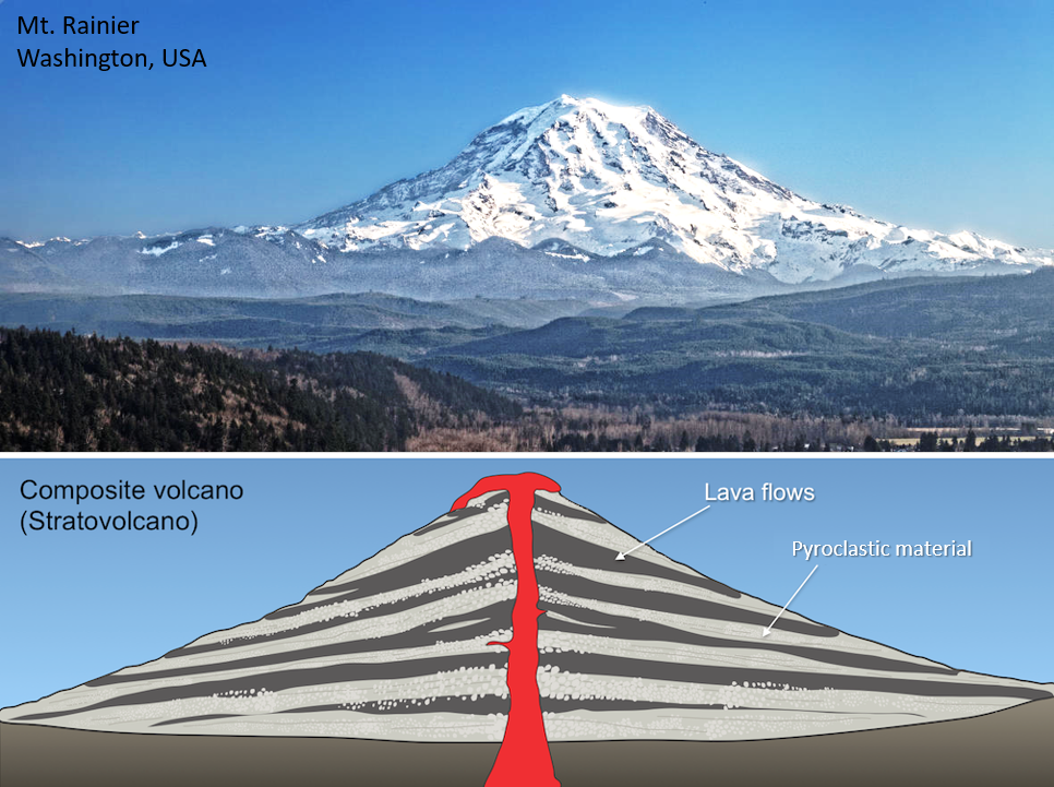
Composite volcanoes, like Mt. Rainier (located in the western U.S. in Washington state; Figure 1C.2.3 top), consist of layers of lava alternating with layers of pyroclastic material (lava blocks, bombs, lapilli, ash, and pyroclastic flow material; Figure 1C.2.3 bottom). The layers (strata) are where the alternative name of stratovolcano comes from. Mt. Rainier displays the characteristic steeply sloped shape of stratovolcanoes and is the tallest stratovolcano in the United States at 4,392 m (14,410 feet). Stratovolcanoes are the classic volcano type most people think of when they hear the word “volcano”. Stratovolcanoes typically erupt higher viscosity andesitic and rhyolitic lavas, which do not travel as far from the vent as basaltic lavas do. This results in smaller diameter volcanoes than shield volcanoes.
Cinder Cones
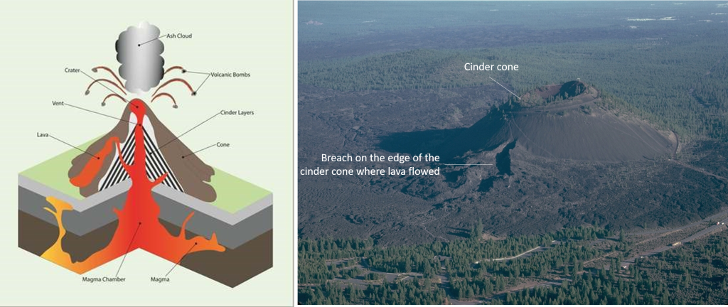
Cinder cones are the smallest of the three and made of small (pea to fist sized) fragments of solidified lava that is full of gas bubbles (these are called scoria, or more colloquially, cinders) that is built up in layers of rubble over time (Figure 1C.2.4 left). Molten rock, gas, and ash is ejected from the vent where it cools and falls to the ground and breaks into small pieces that pile around the vent. These piles of loose cinders have steep straight sides and are typically less than 200 m high, this is much smaller than either shield or stratovolcanoes. While the cone itself is loose fragments, they can produce lava flows that erupt from a fissure or vent in the side of the cone, like is seen at Lava Butte in Oregon (Figure 1C.2.4 right). Cinder cones can be found on their own but can also form around the vents (main and side) on larger shield and stratovolcanoes.
Check your understanding: Volcano types
2.2 Eruption Landforms
Lava Domes
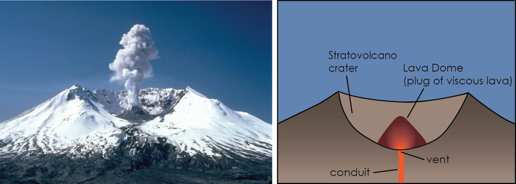
Lava domes are small mounds of lava that solidify around a volcanic vent. Lava domes are formed by relatively small but very viscous (highly sticky!) eruptions of lava. The high viscosity means the lava is not able to flow far and instead solidifies as a steep sided, bulbous plug at the volcanic vent (Figure 1C.2.5 right). While the growth of the dome itself is typically non-explosive/effusive, this plug of magma serves to trap gas inside the volcano and if it collapses this can lead to an explosive eruption and dangerous hazards such as pyroclastic flows. While lava domes can occur on their own, they are more commonly seen as eruptive features either on the flanks or within the crater of stratovolcanoes like seen at Mt. St. Helen’s in Washington (Figure 1C.2.5 left).
Flood Basalts
Flood basalts are massive outpourings of basaltic lava covering broad flat regions of the Earth. The amount of lava involved is far greater than seen at large shield volcanoes with individual eruptions/lava flows capable of being greater than 1000 cubic kilometers. For comparison, Kilauea (shield volcano on Hawaii) has erupted a total of 1.5 cubic kilometers over the past 16 years of eruptions. Instead of erupting from a single vent, these basalts erupt along long fissures, or cracks, in the lithosphere (Figure 1C.2.6). Due to the low viscosity of basalt and the large volume erupted, the lava spreads out into giant lava lakes and cools. The mechanisms leading to flood basalts are not completely understood, but it is widely thought the fissures are fed by a large plume of magma that originates deep in the mantle and in many instances flood basalts are associated with areas of rifting or failed rifting. Flood basalts can occur on ocean floors or on continents.
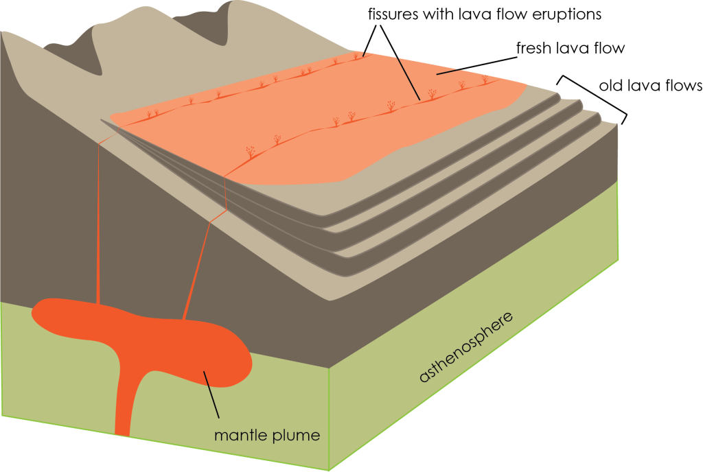
Connection: Hot spot volcanoes are also sourced by mantle plumes (refer to Chapter 1A.3) -but the final landscapes formed from hot spot volcanism look different than flood basalts. Hot spot volcanoes erupt from vents instead of from long fissures, and the magma composition to create flood basalts is basaltic while hot spot volcanoes can have more varied magmas depending on where they are located. For example, the Hawaiian Islands are basaltic while Yellowstone is rhyolitic, but both are the result of hot spot volcanism!
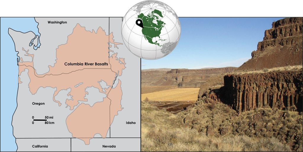
Many rounds of these large eruptions through the same fissure network build up over time creating basalt thicknesses of thousands of feet. A characteristic stair step appearance to the landscape develops as erosion cuts down through the many layers of basalt. This is seen in the Columbia River Basalt Group (CRBG), which is an ancient flood basalt covering a large area of the state of Washington and extends into Oregon and Idaho (Figure 1C.2.7). While this may seem like a large area to be covered by flood basalts, the CRBG is among the smallest (and youngest) continental flood basalts on the planet.
Check your understanding: Volcano types and eruption landforms by sight!
This is a little harder but see if you can identify the volcano types and eruption landforms based on their picture. Remember, cinder cones will be much smaller than stratovolcanoes or shield volcanoes so you can use things like the relative size of trees/bushes to help you! Lava domes will be bulbous mounds and typically associated with a stratovolcano, while flood basalts have a characteristic stair step appearance.
References
Rubin, K. (n.d.) Mauna Loa Volcano. https://www.soest.hawaii.edu/GG/HCV/maunaloa.html
Self, S. & Rampino, M. (n.d.). Flood Basalts, Mantle Plumes and Mass Extinctions. The Geological Society of London. https://www.geolsoc.org.uk/flood_basalts_1
