5. Transform Boundaries

Transform boundaries are where two plates slide side by side past each other on the surface of the Earth, without producing or destroying crust (no divergence or convergence, respectively) (Figure 1A.5.1). The stress type here is shear – like a pair of scissor blades sliding past each other. These boundaries are also called transform faults.

Block shaped diagram with a long line representing the fracture zone/transform fault running from left to right across the middle of the top surface of the diagram (dividing this surface into a front and back half). A mid ocean ridge is on the left in the front half oriented from front to back such that the plates are spreading to the left and right. A second mid ocean ridge is on the right in the back half oriented the same way such that the plates are spread to the left and right. This creates an offset between the two segments of MOR. In the offset area between them, the plates on either side of the middle dividing line are moving in opposite directions (moving right on the front half and left in the back half). This offset area is labeled as the transform fault. To the left of the front MOR the plates are both moving to the left, and to the right of the back MOR the plates are both moving to the right. These two areas are labeled as the fracture zones.
Figure 1A.5.1. Diagram of a transform boundary. This diagram shows the transform boundary in relation to two sections of divergent boundary (MOR = mid ocean ridge). The two MORs are offset from each other and the direction of plate motion on either side of the MORs are shown with black arrows. The segment between the two MORs where the plates are moving in opposite directions as shown by the large white arrows, is the transform boundary. This is the area where lots of earthquakes will occur. Note that as the transform boundary extends out past either MOR, plates will be moving in the same direction, as shown by the thin white arrows. This area is the fracture zone, and it is inactive in terms of earthquakes as pressures do not build up in the same way when plates are moving with each other instead of against each other. Source: Lindsay Iredale (2024) CC by 4.0

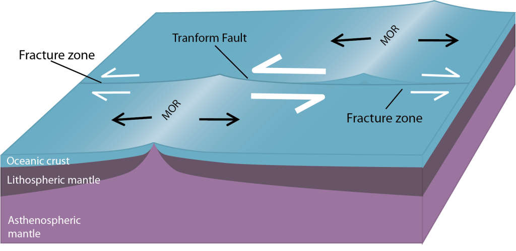
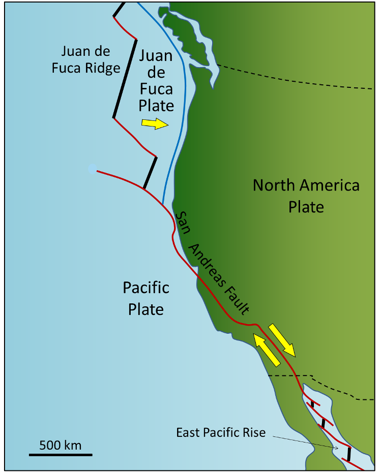
Most transform boundaries tend to be relatively short segments of boundary compared to divergent and convergent boundaries.  They are like “connector pieces” – they join larger segments of the other two boundary types together. Most transform faults connect segments of mid-ocean ridges and are therefore mostly ocean-ocean plate boundaries, this is seen in Figure 1A.5.2 along the Juan de Fuca Ridge and the East Pacific rise.  In these areas, and along all other spreading centers, the transform faults connect offset segments of divergent boundary giving mid ocean ridges a “stair step” appearance.

Some transform faults connect continental parts of plates. The San Andreas Fault is a well know example of this.  It connects the southern end of the Juan de Fuca Ridge, a mid ocean ridge in the Pacific Ocean west of the Pacific Northwest area of the USA, with the northern end of the East Pacific Rise (another mid-ocean ridge) in the Gulf of California. The part of California west of the San Andreas Fault and all of Baja California are on the Pacific Plate.

But transform faults don’t just connect divergent boundaries; it is far less common but they can also connect divergent to convergent boundaries or convergent to convergent boundaries.

Map of the plate boundaries in the western part of North America and into the Pacific Ocean from northern Mexico to southern Canada. The plates involved are the Pacific Plate (in the Pacific Ocean and west of the San Andreas Fault in southern California and Mexico), North American Plate (the rest of North America), and the Juan de Fuca Plate (small plate in the Pacific Ocean off the coast of the Pacific Northwest area of the U.S.). The boundary between the Pacific Plate and the North American Plate through California is marked by a red line labeled as the San Andreas Fault. This is a transform boundary and yellow arrows indicate the North American Plate is moving south while the Pacific Plate is moving north in this area. The Juan de Fuca Plate is moving east and subducting under the North American Plate (convergent boundary). It has offset spreading centers (divergent boundaries) with the Pacific Plate that create a stair step with transform boundaries connecting the offset segments of divergent boundaries.
Figure 1A.5.2. Map of the plate boundaries in the western part of North America and into the Pacific Ocean from northern Mexico to southern Canada. A major transform boundary, the San Andreas Fault, extends from the north end of the East Pacific Rise in the Gulf of California, Mexico to the southern end of the Juan de Fuca Ridge located in the Pacific ocean off the western edge of the Pacific Northwest, USA. Red lines on this map are transform faults, thick black lines are divergent boundaries, blue line is a convergent boundary. Source: Steven Earle CC-BY 4.0. Found here.

Unlike divergent and convergent boundaries, when analyzing the 4 data types transform boundaries are characterized by a lack of any pattern, with the exception of earthquake activity.

5.1 Topographic Features

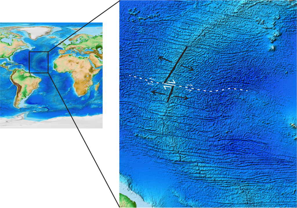
Transform boundaries do not have a single distinctive topographic feature like the other boundary types do.  They are noticeable as a “crack” in the Earth where they connect divergent boundaries along mid-ocean ridges as seen in the enlarged segment of the Mid Atlantic Ridge in Figure 1A.5.3.  On this diagram one pair of MORs is marked in black and offset by a transform boundary marked in white.  There are many more examples of transform boundaries offsetting MORs in this figure.  Can you find any others?

Where transform boundaries are on the continents they don’t have distinct features – they can be cutting through valley areas or cutting across mountains.

Map view of the mid Atlantic ridge with two segments of divergent boundary and one segment of transform boundary marked. There is one divergent boundary to the north and offset to the west from a second divergent boundary to the south, which is farther east. The offset segment is marked by a line indicating the transform boundary location.
Figure 1A.5.3. Enlarged view of a section of the Mid Atlantic Ridge. Along this overall divergent boundary, two offset segments of MOR are marked in black with associated black arrows indicating plate motion moving away from the divergent boundary. These MOR segments are offset along a transform boundary marked in solid white with large white arrows showing the plate motion on either side of this boundary. The dashed white lines with smaller white arrows delineate the inactive fracture zones where plates are moving in the same direction. Source: Lindsay Iredale (2024) CC by 4.0. Topographic map adapted from NOAA. Public Domain. Found here.

5.2 Volcanic Activity

There is no mechanism to generate magma at transform boundaries – no plates are pulling apart to allow the mantle to decompress and upwell and plates are not subducting to generate flux melting.  As a result, volcanic activity is not typically present at transform boundaries themselves.

5.3 Earthquake Activity

Earthquake activity is abundant at transform boundaries. The two plates sliding past each other generate earthquakes that can be very high in magnitude. Just think of the San Andreas Fault; it is know for earthquake activity! These earthquakes are located on the boundary and are shallow (Figure 1A.5.4).  Like divergent boundaries, these earthquakes are shallow because without subduction there is no lithosphere at depth.

5.4 Seafloor Age

There is not a distinct age of seafloor at transform boundaries.  Ages will range from very young when they are located as the connections between divergent boundaries to no seafloor at all if they are located on the continent.

Check Your Understanding: Movement at transform boundaries


Check Your Understanding: Naming plate boundary types and features

Drag and drop the correct label to the correct spot on the diagram below to practice your understanding of Earth’s layers and plate boundaries types and features.  The features to be labeled all have hints in brackets to help you interpret the diagram.

Check Your Understanding: Analyzing data to determine the plate boundary type


License

Icon for the Creative Commons Attribution-NonCommercial-ShareAlike 4.0 International License

Environmental Geology Copyright © 2024 by Lindsay Iredale is licensed under a Creative Commons Attribution-NonCommercial-ShareAlike 4.0 International License, except where otherwise noted.

Share This Book