3. Stream Features and Deposits
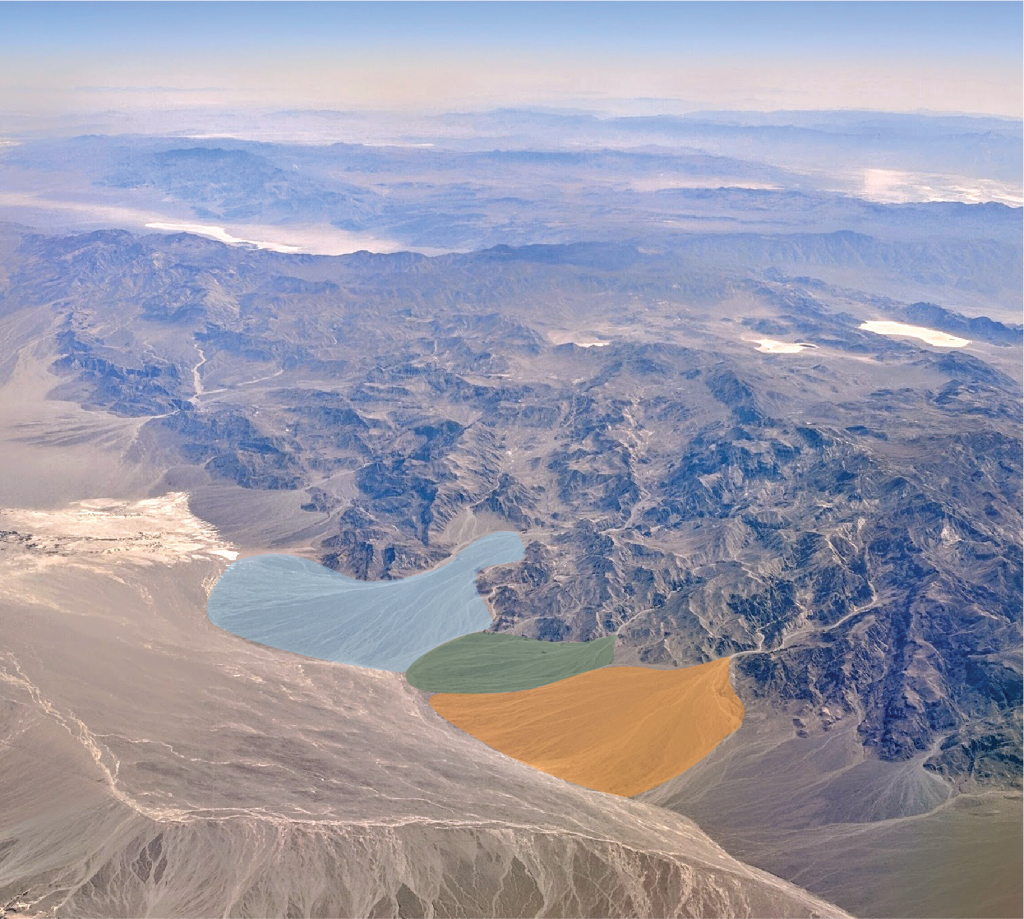
From the headwater zone through to the deposition zone along a stream, changes in stream velocity create distinct erosional and depositional features. As a fast-moving stream flows out of a mountainous, steep area onto a flat valley floor it rapidly loses velocity and deposits some of the sediment it was transporting. This sediment is deposited in distinctive fan or wedge-shaped deposits of gravels and sands called alluvial fans. The photograph in Figure 2B.3.1 shows a series of alluvial fans in Death Valley, California.
As a stream flows out onto the flatter landscape of the deposition zone it develops large S-shaped curves called meanders. These become particularly well developed if the ground the stream is flowing over is soft enough to erode; streams flowing through very hard rocks will not develop meanders as nicely. These curves are surrounded by large, flat floodplains.
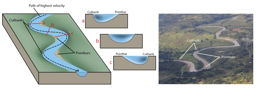
Meanders develop because streams do not flow at the same velocity across their width, which means they do not erode or deposit sediment evenly along their path. The highest velocity flow path in a stream is not straight down the middle of the channel, instead it winds its way across the stream swinging to the far outside edges of the meanders as it flows (Figure 2B.3.2, left, black dashed arrow path). Friction with the stream bed and with the air serve to slow water down and add to the uneven velocities found within a stream channel. These uneven velocities make the stream channel variably shaped along the curves and the straighter portions of the stream path (Figure 2B.3.2, middle). On a curved section of a stream, flow is fastest on the outside of the curve and slowest on the inside of the curve. On a straight section of stream, fastest flow is in the middle of the stream.
This uneven velocity across the stream corresponds to areas of more erosion and areas of more deposition. The outside edges of meanders where velocity is high, are areas of erosion. The stream erodes along the stream bed, making this area deeper, and along the outside edge of the stream bank making the stream bank steeper. This steeply eroded stream bank is called the cutbank (Figure 2B.3.2).
The inside edges of meanders where velocity is lower, are areas of deposition. The stream deposits the larger sediment it is transporting in these areas as sandbars along the inside corners of the meanders. These are called pointbars (Figure 2B.3.2).
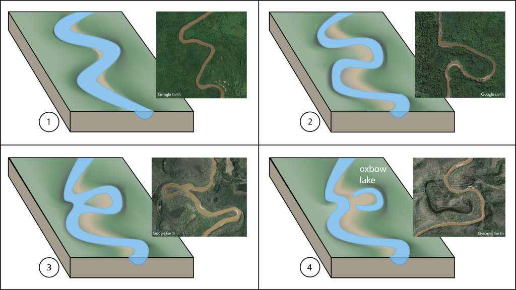
The path of a stream across the landscape is not static, it moves over time. The changing of this path as the stream works its way across the landscape is what carves out the broad flat flood plain that sits beside the stream. In addition, as a stream ages, the meanders grow and become more strongly curving and can eventually become so winding that curves will erode close enough to meet each other, effectively pinching off the meander between them. This cut off curve becomes a little horseshoe shaped lake called an oxbow lake (Figure 2B.3.3).
At the mouth of a stream, where it empties into a body of water such as the ocean or a lake, another wedge-shaped deposit of sediment forms called a delta (Figure 2B.3.4). It is named this because the classic example of this feature is found at the end of the Nile River, where the Nile Delta is shaped like the capital Greek letter delta (a triangle). Not all deltas have this nice triangular shape though; some, like the Mississippi Delta, are more elongated and irregularly shaped. The shape a delta will take depends on the amount of sediment the stream is carrying and how strong the wave action is in the ocean or lake. Regardless of shape, the reason all deltas form is the same; it forms as the stream velocity slows down upon entering the body of water causing the sediment it was transporting to be deposited. Sediment deposited in a delta is typically finer grained sands and silts, as the coarser sands and gravels have usually been deposited long before reaching the mouth of a stream.
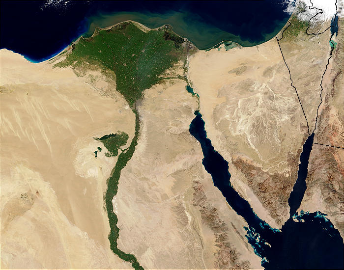
Wetland areas commonly form on deltas as the region is constantly supplied with water and nutrients. Many major populations are located on deltas as they provide access to ocean and river trade. In addition, the fertile soil and abundance of water make good agricultural areas. In the case of the Nile Delta in Egypt, the river and the delta are home to most of the population as they are the easiest access to any water in this desert region as seen by the distinct change from sandy desert to lush green plants in the photograph in Figure 2B.3.4.
Check your understanding: Identify river features
