2. Plates and Plate Boundaries
Continental landmasses move around on the planet. They have not always been in their present locations, nor will the landmasses be in this configuration forever – they are constantly moving, albeit slowly, because they are part of larger pieces of lithosphere that are constantly in motion. How these pieces of lithosphere move and interact is the Theory of Plate Tectonics.
Plate Tectonics is the unifying theory of Geology. Everything in geology can be related and understood in a logical context if you understand Plate Tectonics – think of it like the “Kevin Bacon of Geology” (go to this wikipedia page if you don’t understand that reference and then try it out for yourself at the oracleofbacon.org). Because of this, it is probably the single most important thing to learn about geology (the rest of it is important too, just not as fundamental to how we understand the Earth). It is the equivalent of learning evolution in the life sciences.
2.1 The lead up to Plate Tectonics
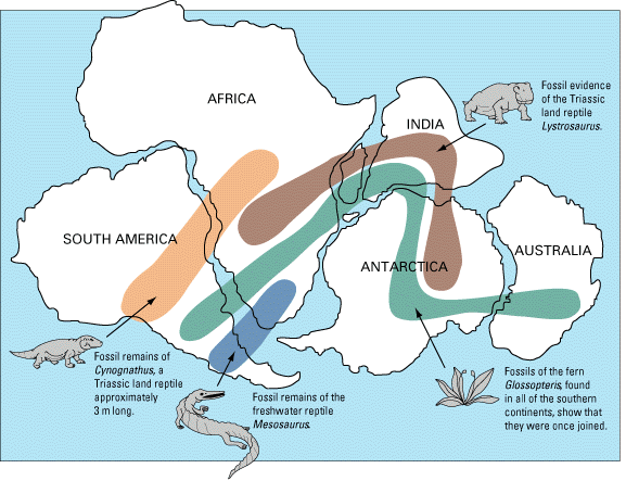
The understanding of how continental landmasses moved came about over 100 years ago. In 1912, a German meteorologist named Alfred Wegener proposed a theory he called Continental Drift when he observed that the continents (and fossil locations/mineral belts/mountain belts/glacial features/etc.) all joined up nicely along their edges if we fit them back together – like a jigsaw puzzle (Figure 1A.2.1). Wegener proposed that the continents had all been joined into one large supercontinent in the past, which he called Pangea. His theory was not widely accepted at the time because while he had the evidence to show the continents had been joined and have since moved apart, he did not have a valid mechanism by which they could move.
Remember that at this time, as far as anyone knew, Earth’s crust was continuous; not broken into plates. Therefore, any mechanism Wegener could think of would have to fit with that model of Earth’s structure. Geologists at the time were aware that continents were made of different rocks than the ocean crust, and that the material making up the continents was less dense, so Wegener proposed that the continents were like icebergs floating on the denser ocean crust. He suggested that the continents were moved by the effect of Earth’s rotation pushing objects toward the equator, and by the lunar and solar tidal forces, which tend to push objects toward the west. However, it was quickly shown that these forces were far too weak to move continents and without any reasonable mechanism to make it work, most geologists of the day quickly dismissed Wegener’s theory.
Further evidence supporting the movement of continents came during WWII with advances in sonar, which was used to map topography of the ocean floor. This led to the first detailed maps showing important seafloor features such as mid ocean ridges and deep-sea trenches. A Princeton geology professor and naval officer during WWII, Harry Hess, mapped and studied the patterns of seafloor features and suggested a theory to explain how the continents moved. While not the name he chose at the time, this theory became known as Sea Floor Spreading and suggested that new ocean floor is created at mid ocean ridges and old ocean floor is destroyed at deep sea trenches, thereby keeping the Earth at a constant size. Sea Floor Spreading combined with Continental Drift form the basis for the Theory of Plate Tectonics.
The modern Theory of Plate Tectonics was only solidified into its current, most coherent, form in the 1960s. In terms of scientific theories/knowledge, this is a pretty young theory still! This became widely accepted by 1965,completely changing the way geologists view the Earth, and finally giving geologists a coherent theory that could explain all the geologic phenomena they saw.
2.2 Theory of Plate Tectonics
The basic principles of Plate Tectonics state:
- Earth’s surface is divided into rigid plates (pieces) of lithosphere,
- These lithospheric plates float on top of the asthenosphere,
- The plates move independently of each other,
- The plates interact with each other at their plate boundaries (edges of the plates), and
- Plate interiors are generally geologically stable and most of the geologic activity (mountain building/earthquakes/volcanoes/etc.) happens at plate boundaries where plates are interacting.
The Plates
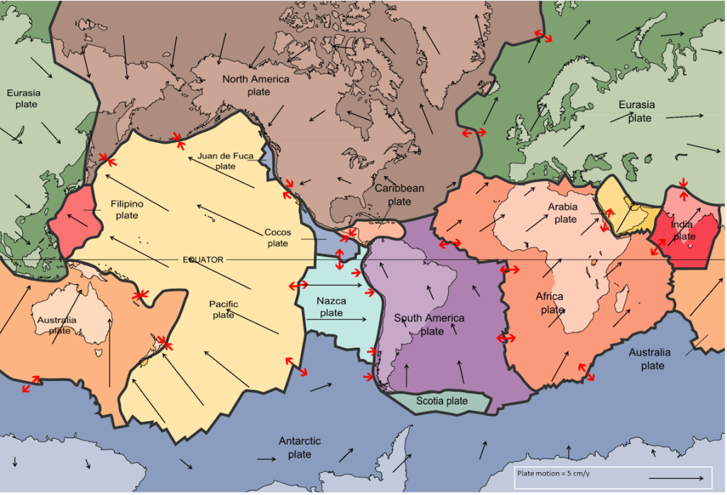
By the end of 1967, Earth’s surface had been mapped into a series of plates (Figure 1A.2.2). The major plates are Eurasian, Pacific, Indian, Australian, North American, South American, African, and Antarctic plates. There are also numerous small plates (e.g., Juan de Fuca, Nazca, Scotia, Philippine, Caribbean), and many very small plates, or sub-plates.
The plates are named based on their general region in the world, i.e. the African Plate has the African continent in it. But note that the edges of the plates (plate boundaries) do not simply line up with the edges of continents or edges of oceans for which they are named, i.e., the Pacific Plate is most of the Pacific Ocean, but not all of it. The Cocos Plate, Nazca Plate, and Juan de Fuca Plate are smaller plates on the eastern side of the Pacific Ocean. In addition, the plates that have continental landmass (and therefore continental crust) contain a combination of ocean and continent on them. An example of this is the North American Plate – it includes all of the North American continent, but also extends west through the Bering Sea and into Siberia, and east including all of Greenland, the western portion of Iceland, and half of the North Atlantic Ocean.
Plate motions can be tracked using Global Positioning System (GPS) data from different locations on Earth’s surface. Rates of motions of the major plates range from less than 1 cm/y to more than 10 cm/y (Figure 1A.2.2). The Pacific Plate is the fastest, moving at more than 10 cm/y in some areas, followed by the Australian and Nazca Plates. The North American Plate is one of the slowest, averaging ~1 cm/y in the south up to almost 4 cm/y in the north. To put this in perspective, this is about the same rate fingernails grow.
Plates move as rigid bodies, so it may seem surprising that the North American Plate can be moving at different rates in different places. The explanation is that plates rotate as they move (and geometry on a sphere is not quite as simple as on a flat surface!). The North American Plate, for example, rotates counterclockwise, while the Eurasian Plate rotates clockwise.
Practice reading the Plate Boundary Map
Plate Boundaries
Plates interact at their boundaries in one of three ways: plates are moving away from each other (divergent), plates are moving towards each other (convergent), or plates are sliding past each other side by side (transform). Plates move along the lithosphere-asthenosphere boundary and because the asthenosphere is relatively weak it deforms as the plates move rather than locking them in place. Even though the plates are in constant motion, and move in different directions, there is never a significant amount of space between them.
Check your understanding: Plate Boundaries
The next 3 sections in this chapter will each cover one of the plate boundary types with details on plate motion and the geologic features/processes that characterize the boundary. For each boundary type, four key pieces of information will be discussed: topographic features, volcanic activity, earthquake activity, and seafloor age. Every plate boundary on the planet can be accurately identified by analyzing just these four pieces of information.
