4. Plate Tectonics and Volcanism
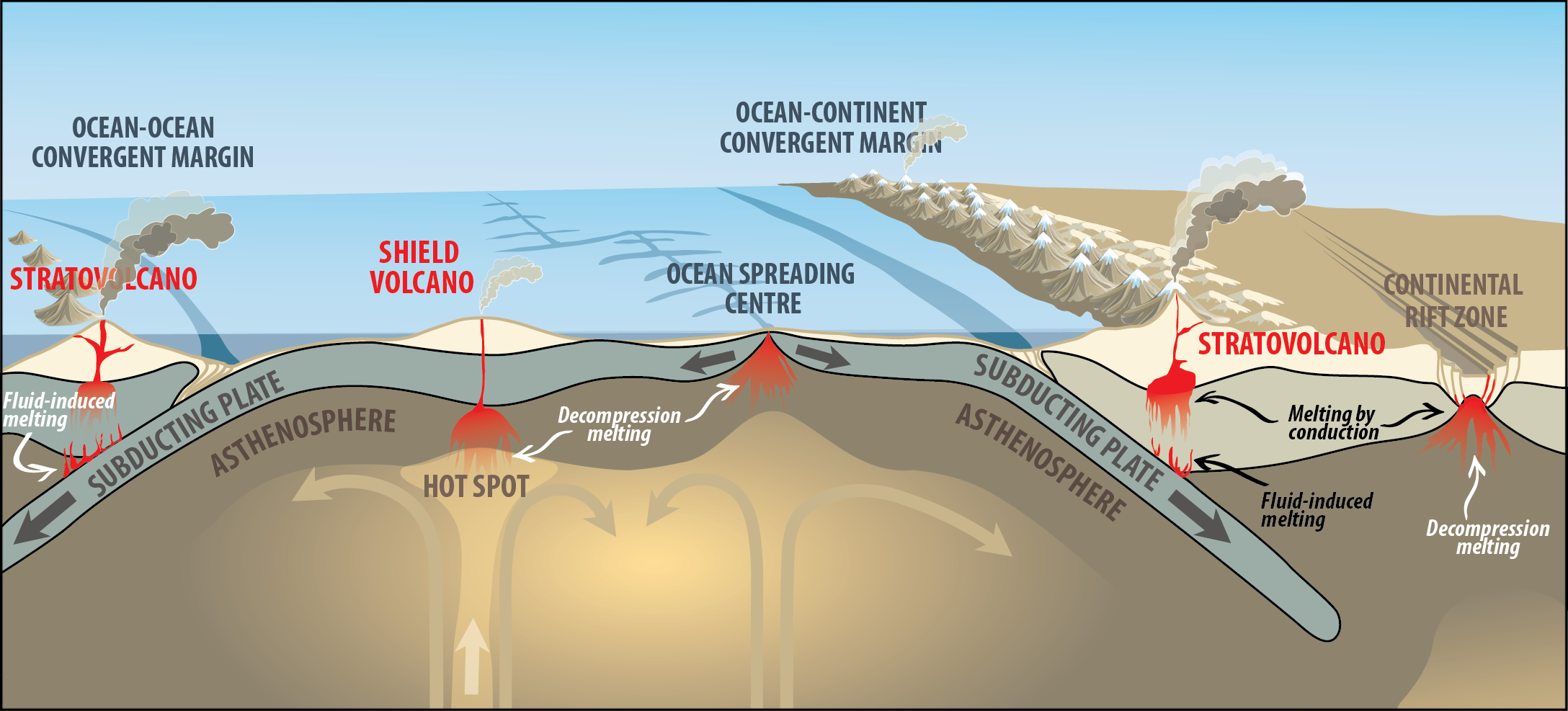
Volcanic eruption styles and types and the materials and hazards produced during eruptions can all be tied together into a big picture by considering the plate tectonic settings in which magma forms (Figure 1C.4.1). Tectonic plates are the dominant controlling factor for volcanism, and as such most volcanic activity is present along plate tectonic boundaries (you can review the ways in which magma is formed in these areas in Chapter 1A).
There are five main scenarios to consider that create distinct types of volcanism:
- Subduction zones: ocean-ocean and ocean-continent convergent boundaries
- Mid Ocean Ridges: divergent boundaries in the ocean
- Oceanic hot spots
- Continental hot spots
- Continental rifting: divergent boundaries on land
4.1 Subduction zone volcanoes
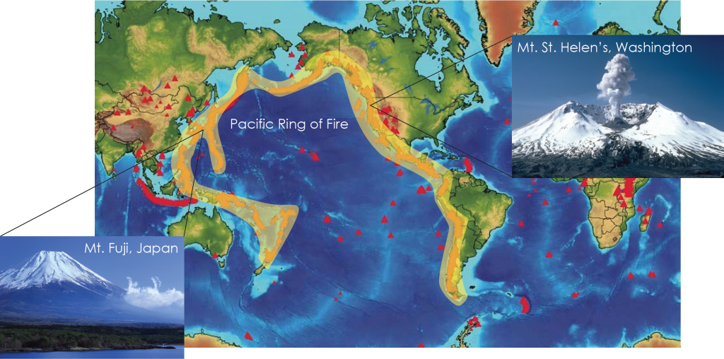
Most volcanoes on the planet form at subduction zones (ocean-ocean convergent and ocean-continent convergent boundaries). The magma generated here is a result of flux melting in the mantle, where volatiles such as water are supplied from minerals in the subducting plate into the asthenosphere and cause melting. the Pacific Ring of Fire, which is the dense line of volcanoes associated with the subduction zones surrounding the Pacific Ocean is a result of this. The magma generated at these locations is commonly (but not exclusively) intermediate (andesitic) in composition leading to large, explosive stratovolcanoes like Mt. Fuji and Mt. St. Helen’s (Figure 1C.4.2). Approximately three quarters of the volcanoes on the planet are found along the Ring of Fire.
4.2 Mid Ocean Ridge Volcanoes
At ocean divergent boundaries, magma is generated through partial melting as decompression occurs generating basaltic magma (see Chapter 1A for review on decompression melting and partial melting). Basalt erupted along MORs forms new oceanic crust. At most mid ocean ridge locations, the volcanic activity does not rise above sea level and the basalt is solidified into pillow basalts on the ocean floor. If the volcanic activity does rise above sea level, the basalt spreads out to create shield volcanoes.
4.3 Oceanic Hotspot Volcanoes
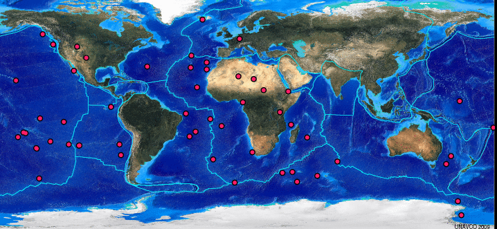
Plate interiors are quite stable but intraplate volcanoes do occur as a result of hotspots. Remember, hotspots are where mantle plumes bring magma generated deep into the mantle up to the surface. As plates move overtop of these plumes, chains of volcanoes are created (refer to Chapter 1A.3). There are many hotspots on the planet as shown in Figure 1C.4.3, some of which are found underneath continents (see section 4.5 below), but most of which are underneath the ocean, such as Hawaii.
The magma in mantle plumes is basaltic which leads to chains of large shield volcanoes at oceanic hotspots. A classic example of this is the Hawaiian Islands chain. The Hawaiian Islands are part of a much longer chain of islands (now mostly eroded and underwater) called the Emperor Seamount-Hawaiian Ridge (Figure 1C.4.4). The active hotspot is located southeast of the big island of Hawaii, in about the location of Loihi on the inset map. This hotspot is currently supplying the active volcanoes on the big island. All the other islands in the chain have moved off of the hotspot and are now extinct volcanoes.
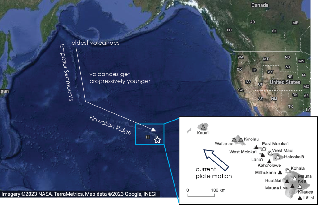
Loihi is the newest volcano in the Hawaiian chain. As of now, the volcanism is still below sea level, but with continued growth, it will one day be above sea level and the basalt will flow long distances and build another shield volcano in the Hawaiian Island chain!
4.4 Continental Hotspot Volcanoes
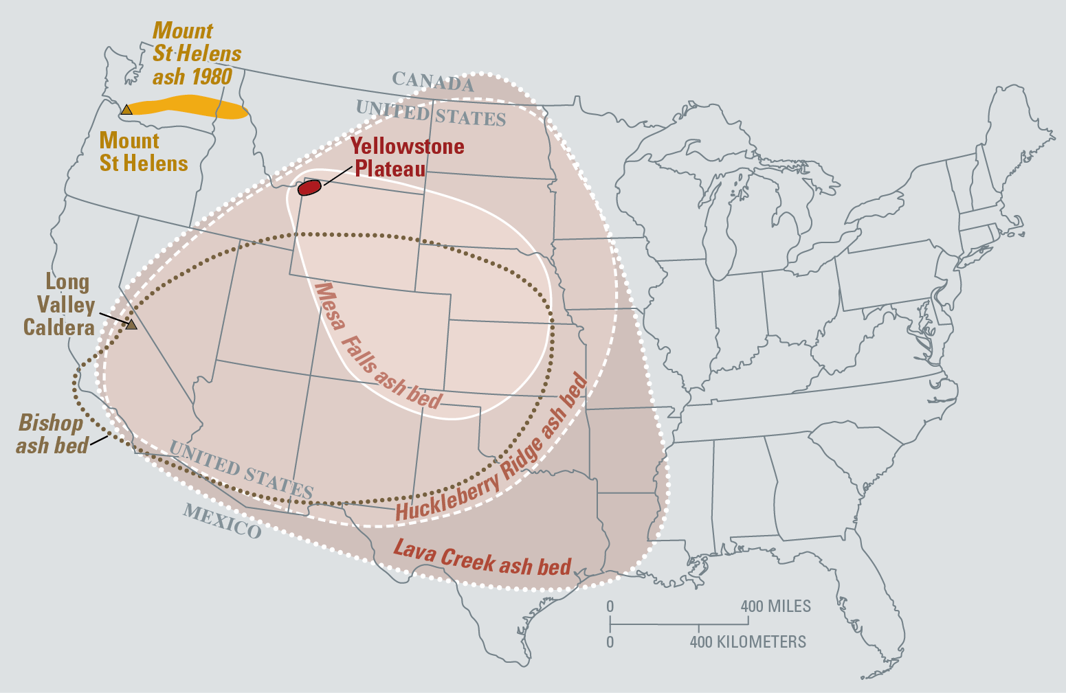
Volcanism associated with continental hotspots can vary from explosive rhyolitic volcanoes to large flood basalts. Where mantle hotspots cut through continental lithosphere instead of oceanic lithosphere, the magma composition can change from the original basaltic magma in the plume. As basaltic magma rises through the lithosphere it can incorporate parts of continental lithosphere and become much more felsic in composition. This is the case with the hotspot underlying the Yellowstone area of the western U.S. This area of continental crust is mountainous and thick, so the plume can become rhyolitic which results in very explosive eruptions. In addition, the Yellowstone area has super-eruptions (which is a fantastical term simply meaning the magma chamber is extremely large compared to a typical volcano and therefore the amount of material that is ejected is immense) – which sometimes leads to these massive caldera forming eruptions being called supervolcanoes. But the highly explosive magma, combined with a larger than usual magma chamber has made for exceptionally large eruptions in the past! Figure 1C.4.5 shows the extent of ashfall from the two most recent super eruptions of Yellowstone 2 million years ago (Huckleberry Ridge), 1.3 million years ago (Mesa Falls) and 640,000 years ago (Lava Creek). The largest of these ash falls covered two thirds of the continental United States. This is compared with the much smaller ash from Mt. St. Helen’s, which as was learned, was still a major eruption.
Continental hotspots also create a chain of volcanoes, or more often called a hotspot track when on the continent, which can be used to see plate motion. The map below shows the hot spot track of the Yellowstone hot spot, which created a series of lava flows in the Snake River Plain area (Figure 1C.4.6).

Hotspots under the continents can also produce flood basalts, such as the Columbia River Basalt, which is located west of the Yellowstone hotspot track. In this case, the area is near the western U.S. where oceanic lithosphere is subducting to the east under the continent. It is thought a slab of previously subducted lithosphere was lifted by the rising mantle plume and became trapped under the continental lithosphere allowing a large volume of magma to build up here. The timing of this coincides with a break in any Yellowstone hotspot activity approximately 20 million years ago. This accumulated magma finally broke through around 17 million years ago and flooded the landscape as the Columbia River Basalts. Following this, activity along the Yellowstone hotspot resumed as normal.
4.5 Continental Rift Volcanoes
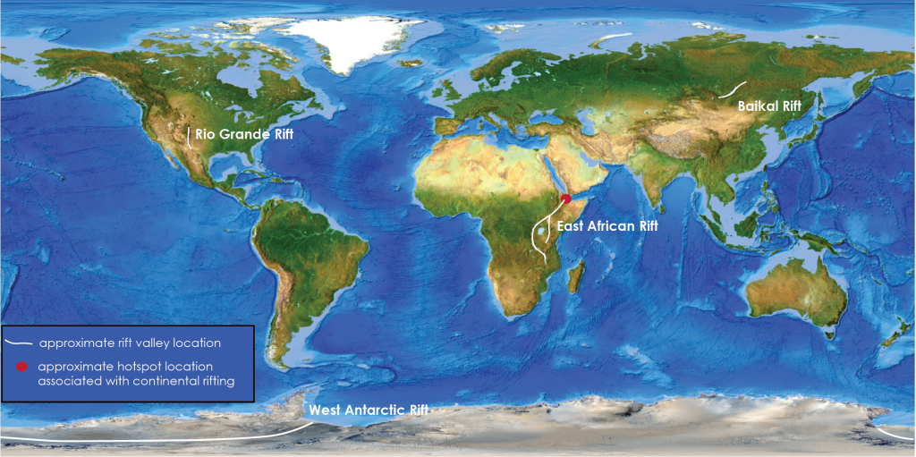
Like continental hotspots, continental rifting is not defined by a single style of volcanism. The volcanism in these areas can range from shield volcanoes, to cinder cones, to stratovolcanoes, to flood basalts. There are very few active continental rifts currently, with the East African Rift, the Baikal Rift, the West Antarctic Rift, and the Rio Grande Rift being the major ones. Some areas of continental rifting, notably the East African Rift Zone, coincide with hotspots, while others, like the Baikal Rift do not (Figure 1C.4.7).
Check your understanding: Volcanism and plate tectonics
References
U.S. Geological Survey (2021). Just how long has the Yellowstone Hotspot been around? https://www.usgs.gov/observatories/yvo/news/just-how-long-has-yellowstone-hotspot-been-around
