5. Monitoring Eruptions
The activity level of volcanoes is described using three terms:
- Active: volcano is erupting, has recently erupted, or is likely to erupt
- Dormant: volcano has not erupted in hundreds to thousands of years but is still capable of erupting
- Extinct: volcano is no longer capable of erupting
As volcanoes transition from being dormant to being active, there are distinct and measurable signals. Scientists monitor and measure these signals to make determinations about how soon an eruption will occur and therefore when to let people know to evacuate an area.
The three main factors scientists monitor are landform changes, seismic activity, and gas leaks/composition changes.
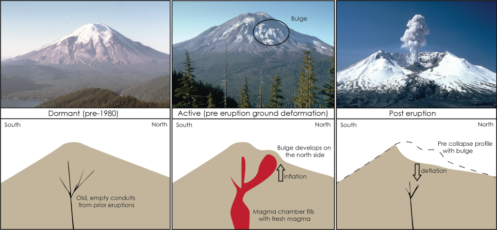
5.1 Landform Changes/Ground Deformation
As magma starts to move into the magma chamber it causes the land to bulge or inflate like a balloon. Following an eruption, once the magma has left the magma chamber, the landscape falls again, or deflates. These changes to the landscape are referred to as ground deformation.
Ground deformation is measured either using a tiltmeter, which is a sensitive three-directional level that can detect small changes in the tilt of the ground at a specific location, or by using GPS (global positioning system) technology. At the USGS Hawaiian Volcano Observatory both are used to monitor activity at Kilauea and Mauna Loa (the two active Hawaiian volcanoes). Tiltmeters provide effective short-term monitoring (day to day and week to week), while GPS is more effective at long time scales (changes over several months and years). GPS can also provide detailed information about exactly how far a specific ground location has moved in east-west, north-south, and up-down directions.
Ground deformation was evident leading up to the May 18, 1980, eruption of Mt. St. Helen’s. Prior to the eruption, Mt. St. Helen’s was conical in shape but as magma started to fill the magma chamber and inflate, the ground shifted with a noticeable bulge forming on the northern flank of the volcano. This bulge appeared approximately one month prior to the eruption. Elevation in the bulge was 450 ft higher than before the magma intrusion began. In late April 1980, the bulge was increasing at a rate of 5 ft per day! An earthquake associated with the volcanic activity created a landslide causing this bulge to slide downhill. This released the built-up pressure resulting in Mt. St. Helen’s erupting partially sideways out of the north side of the mountain. The eruption created a distinctive asymmetric, horseshoe shaped crater that opens to the north side (Figure 1C.5.1).
5.2 Seismic Activity
As magma moves underground and fills magma chambers, it must make room for itself. During inflation it flows and squeezes into cracks pushing the rock around it upwards and outwards. This shifting of the rock generates earthquakes as does the rumbling movement of the magma itself. Earthquakes associated with volcanic activity are relatively small, less than magnitude 5 with most being less than magnitude 3. These are small enough to not necessarily be noticed by people living near a volcano, but sensitive seismic equipment can detect them. As activity on a volcano is detected, a series of seismometers are deployed in the area to monitor earthquake activity.
As magma continues to fill the magma chamber and rise towards the surface the location of earthquakes also rises. Earthquake activity tends to increase in intensity (magnitude and frequency) as well as get shallower leading up to an eruption.
During the deflation phase following an eruption, earthquakes continue as rocks shift and collapse within the magma chamber.
At Mt. St. Helen’s earthquakes began in mid-March 1980, two months before the major eruption. A smaller eruption occurred on March 27 prior to the main even on May 18. During the two day time period from March 25-27, there were 174 earthquakes recorded under Mt. St. Helen’s with magnitudes greater than 2.6. Hundreds of smaller earthquakes also occurred in this time frame. Earthquake activity continued through the two months, mostly focused in a shallow area underneath the bulge on the north flank. A particularly large magnitude 5.1 earthquake was the catalyst for the landslide which ultimately “uncapped” Mt. St. Helen’s and caused the main eruption.
Check your understanding: Volcanic seismic activity
Watch the video and answer the questions that pop up.
5.3 Detecting Gases
Water vapor, carbon dioxide (CO2), and sulfur dioxide (SO2) are common gases emitted from volcanoes. Steam blasts (also called phreatic eruptions) can occur when hot magma intruding at depth reacts with groundwater which explosively flashes to steam. These steam blasts indicate the presence of fresh hot magma in the magma chamber.
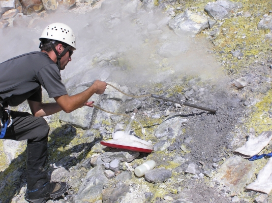
While steam blasts are easily visible, CO2 and SO2 require special sensors to measure them. Changes in the composition or emission rate of gas mixtures rising from fumaroles and larger vents can signal a change in the magma supply below the surface. Gases can be monitored in a variety of ways. Instruments that measure CO2 and SO2 can be mounted on aircraft that fly through clouds of emissions collecting data. These same instruments can also be used on the ground around fumaroles and vents. Some instruments provide immediate readings of gas concentrations while others collect gas samples for more detailed analysis in a laboratory (Figure 1C.5.2). It is also possible to measure SO2 from space using special instruments on board satellites.
5.4 All Together Now!
By monitoring these factors and combining that information with careful observations made on the ground and from the air, geologists can rate the activity of volcanoes on the Volcano Alert Level (Figure 1C.5.3). This can help authorities make decisions about when to issue warnings and evacuations to the public.

Normal (green): Non-erupting volcano exhibiting typical background activity (can include steaming, seismic events, or degassing within normal background ranges).
Advisory (yellow):Volcano is exhibiting signs of elevated unrest above known background activity.
Watch (orange): Volcano is exhibiting heightened or escalating unrest with increased potential of eruption, timeframe uncertain OR an eruption is underway that poses limited hazards including no or minor volcanic-ash emissions.
Warning (red): Volcanic eruption is underway that poses limited hazards to ground-based communities but includes significant emission of ash into the atmosphere that could affect aviation OR major volcanic eruption is imminent, underway, or suspected with hazardous activity both on the ground and in the air.
Check your understanding: Monitoring volcanic eruptions
References
U.S. Geological Survey (1997). MSH Reawakening and Initial Activity. https://pubs.usgs.gov/gip/msh/reawakening.html
