2. Where do earthquakes occur?
2.1 Plate Boundary Earthquakes
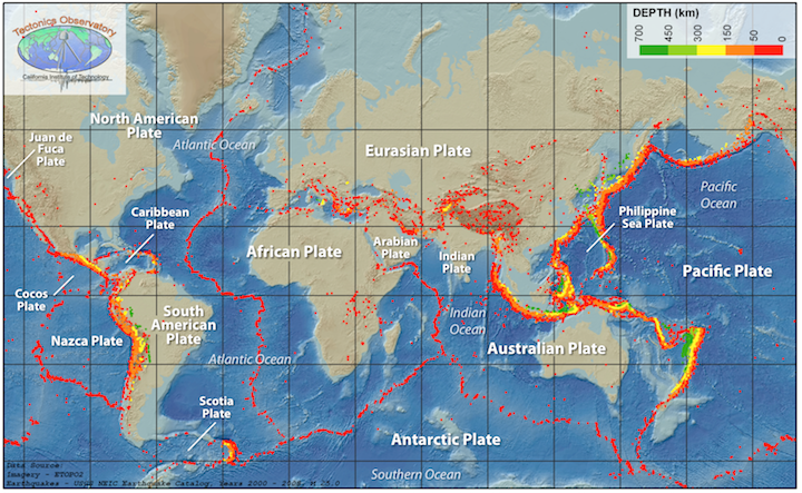
As detailed in Chapter 1A, bands of earthquakes trace out plate boundaries (Figure 1B.2.1, colored dots). The depths of earthquakes and the width of the band depend on the type of plate boundary. Mid-ocean ridges and transform margins have shallow earthquakes (usually less than 30 km deep) in narrow bands close to plate margins. Subduction zones have earthquakes at a range of depths, with the shallowest earthquakes occurring near or on the plate boundary and getting progressively deeper into the overriding plate side of the boundary as earthquakes occur all along the subducting plate which extends beneath the overriding plate. Wide swaths of scattered earthquakes may correspond to continent-continent collision zones.
Most earthquakes occur associated with a plate boundary. However, earthquakes can occur in areas not associated with plate boundaries as well.
2.2 Intraplate Earthquakes
Intraplate earthquakes (within-plate earthquakes) are those that occur away from plate boundaries. Some intraplate earthquakes are related to human activities. When humans trigger earthquakes it is referred to as induced seismicity. These are commonly a result of mining activity as excavating can change the stress in surrounding rocks triggering an earthquake or due to hydraulic fracturing operations where injecting high pressure water mixtures can increase stress along existing faults causing them to slip. Human induced seismicity tends to be smaller in magnitude (less than 4).
Intraplate earthquakes not related to human activities often occur along ancient rift zones. A well-known example of this in North America is the New Madrid Seismic Zone. It is the most naturally seismically active area east of the Rocky Mountains and is in the Mississippi River Valley area (Figure 1B.2.2).

The faults that underlie the New Madrid Seismic Zone are the result of a failed continental rift through the area 600 million years ago. At that time North America was being pulled apart, much like Eastern Africa is today, creating faults and a long linear continental rift valley. That rifting stopped before North America pulled apart enough to create an ocean basin, and the rift valley landscape was then filled in with sediments eroded off the land and brought to the area by rivers (Figure 1B.2.3).
Since 1974, thousands of small to moderate earthquakes have been recorded in this area. While the faults themselves are not visible on the ground surface as they are covered with sediment, the pattern of earthquake epicenters marks out the fault locations.
The New Madrid Seismic Zone is very far from any present-day active plate boundaries, but the tectonic forces from plate boundaries are transmitted into the interiors of continents creating pressure that can reactivate these ancient faults and cause earthquakes. It is much easier to cause rocks to slip along an existing fault like those underlying the New Madrid Seismic Zone, than it is to make new faults altogether!

Refresher on earthquake patterns and plate boundaries
