5. Water Diversions and Dams
To divert water from rivers, such as happens along the Colorado River, diversion structures and/or dams are constructed. In Figure 2B.4.5 three major water diversion structures (aqueducts) in the Lower Basin are shown as purple lines. Aqueduct projects all along the river are used to divert water to major cities such as Denver, Salt Lake City, Phoenix, and Los Angeles, among others. The Colorado River Aqueduct is the primary source of drinking water for Los Angeles, and without it, southern California would not be able to support the population it does. The Colorado River Aqueduct and the All-American Canal also supply a large amount of the water necessary for agriculture throughout southern California.
The Colorado River Aqueduct winds 242 miles to bring water from Lake Havasu, behind the Parker Dam on the Arizona-California border, into southern California (Figure 2B.5.1). About one quarter of its path is through open canals, and the rest is through tunnels and enclosed conduit. Along its path the water travels through 5 pumping stations that lift it up over mountains on its way to California.
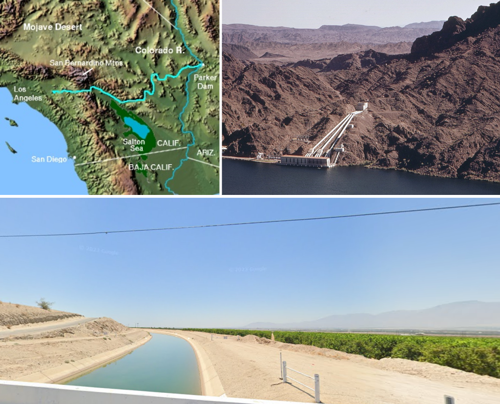
The All-American Canal distributes water from behind the Imperial Dam into the Imperial Valley of southern California, where it is mainly used for agriculture (growing two-thirds of wintertime vegetables eaten in the U.S.). This canal also contains a mix of closed conduit, tunnels, and open canals flowing through a desert area.
These major aqueduct projects pull water from manmade lakes (reservoirs) along the river created by dams. As discussed in the previous section, these reservoirs are important safeguarding measures that hold large stores of water for times of lower flows along the river and ensure there is enough water to meet the needs of all the water users. Dams can provide a multitude of benefits beyond their contribution to storage and diversion for agricultural uses. Dams can contribute to flood control, produce hydroelectric power, and create recreational opportunities on reservoirs.
While dams and diversion projects do play a key role in supplying water for agriculture, thereby increasing food security, particularly in drought areas, they also have many drawbacks. Several of the major drawbacks are discussed below, however, this is not an exhaustive discussion of all the negative aspects associated with dams.
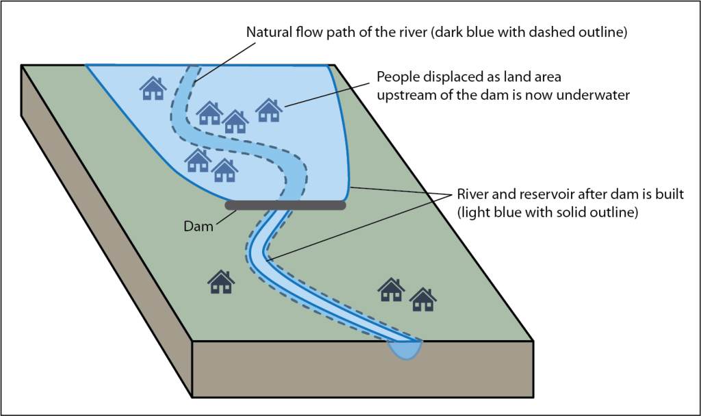
When dams are built, they block the natural flow of the river, which means water piles up and inundates the land behind a dam to create a reservoir (Figure 2B.5.2). A reservoir takes up much more space than a river, and it is estimated that 80 million people worldwide have been displaced as their towns and villages are now underwater in a reservoir.
The larger surface area of water in a reservoir also exposes more water to the sun, heating the reservoir water and increasing evaporation. The evaporation affects the local climate around the reservoir, which can affect temperature fluctuations and ecosystems. This can lead to altered precipitation patterns in the area creating heavier than normal rainfall around the reservoir increasing the risk of flooding or overwhelming the dam. In addition, it may alter the moisture that moves to surrounding areas and farmland, altering the natural rainfall they depend on.
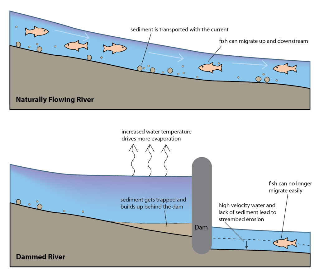
Dams are designed to halt the flow of river water, which means sediment being transported in the river builds up behind a dam as the water slows and deposition occurs. The trapped sediment and higher water temperatures in the reservoir contribute to high nutrient content in the water, which feeds aquatic plant growth and alters the chemical makeup of the water, lowering water quality and even leading to toxic algal blooms. The chemical changes to the water often include lower oxygen levels and higher salinity levels that aquatic species are not adapted to live in (Figure 2B.5.3). In low oxygen conditions, methane is created and released by microbes and decomposition of plant material in the reservoir.
Water that is released from a dam to flow downstream has higher than normal velocity and little sediment. This increases the erosion rates downstream and causes river channels to cut deeper than they otherwise would, increasing discharge rates from groundwater. This accelerates the depletion of groundwater from important aquifers (Figure 2B.5.3).
The lack of sediment in the downstream water is also detrimental to farmland on the downstream flood plains. Yearly flood events help resupply important nutrients to flood plains when flood waters deposit sediment in these areas. Without that sediment, the soil is deprived of an influx of nutrients which leads to a dependence on chemical fertilizers or letting the soil become barren.
The presence of dams fragments the natural river ecosystem, disrupting fish and bird migration (Figure 2B.5.3). Fish species such as sockeye salmon travel upstream to spawn, but dams can block this passage altogether resulting in population loss. While fish ladders are designed to help migrating fish navigate past dams, they are only about 60% effective, with some species navigating fish ladders better than others.
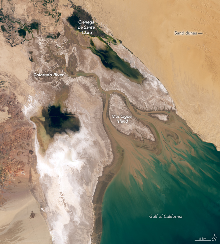
The natural discharge of a river increases downstream as tributaries supply more water to a river. Overall, this means rivers carry more water and get larger as they reach their mouths. However, in rivers such as the Colorado River, where dams and the water diversion projects remove more water than the natural flow can support, the opposite happens, and instead rivers become smaller towards the mouth. In the case of the Colorado River, there is not enough flow left in the river for it to reach the Gulf of California (Figure 2B.5.4). Following the Colorado River Compact, flows along the Colorado River declined, and in the 1960s-1980s, as Lake Powell filled behind the Glen Canyon Dam, the river stopped regularly reaching the Gulf of California. What should be a lush wetland covering the delta is instead a dry bed of sand.
Wetlands are important ecosystems for the planet. They have a huge amount of biodiversity and play a vital role in mitigating climate change by removing and storing carbon dioxide from the atmosphere. In addition, wetlands act like sponges, absorbing excess water and helping to prevent floods.
In the case of the Colorado delta, it may not be a thriving wetland anymore, but it is also not dead. Intermittent, unintentional releases of water from dams since the 1960s have allowed water to reach the delta irregularly, but this has been enough to keep the delta alive. Non-profit environmental groups have been working since the late 1990s to push for regulated yearly small flows (“pulse flows” that are less than 1% of what the historic normal flow to the delta would have been) of water to be released allowing the delta to recharge with water and nutrients. Finally in 2014, the importance of this was recognized and an agreement was reached for releasing water from the Morelos Dam (last dam at the Mexico border) and allowing it to flow to the delta. The pulse flows are timed with when important seeds, such as cottonwoods, are ready to germinate to promote replenishment of the flora.
The agreement between Mexico and the United States highlights an important political issue surrounding reservoirs: international water disputes. The power dynamics between nations over who controls resources is a major source of global conflict and wars.
Check your understanding: Issues associated with dams
Drag and drop the terms from the right-hand side into the column they are associated with: features upstream of a dam, downstream of a dam, or in a naturally flowing river.
Dams have a life expectancy of 50-100 years. The upper end of that can be reached if the dam is constructed properly and continued safety monitoring, maintenance, and repair are completed. The era of large-scale dam building in the U.S. was from the 1930s through the 1960s. This puts the average age of dams in the U.S. around 65 years old, which means many of them are headed towards the end of their lives. Much like humans, as dams age things start to deteriorate, and the risk of catastrophic failure goes up. Most dams in the U.S. were built at a time when climate was very different than today, and many are not up to the challenge of managing the unpredictable and fluctuating precipitation that climate change has brought, limiting their ability to control floods.
References
Hershey, H., (2021). Updating the consensus on fishway efficiency: A meta-analysis. Fish and Fisheries. 22(4). 735-748. https://doi.org/10.1111/faf.12547
