4. Convergent Boundaries
Convergent boundaries occur where two plates are moving toward each other. The stress type at these locations is compression – the “pushing together” stress.
Convergent boundaries are categorized into three subtypes, depending on whether ocean or continental crust is present on either side of the boundary. The subtypes are ocean-continent, ocean-ocean, and continent-continent. Unlike divergent or transform boundaries, the subtype of convergent boundaries is important to distinguish because the features, in terms of topography, earthquakes, volcanoes, and seafloor age, vary depending on the subtype.
4.1 Subduction Zones
Ocean-continent convergent and ocean-ocean convergent boundaries have similar features and processes and can be more generally referred to as subduction zones.
Ocean-Continent Convergent Boundaries
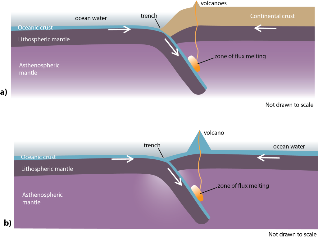
At an ocean-continent convergent boundary, an oceanic plate and a continental plate are moving toward each other. The oceanic plate is subducted, or travels down beneath the continental plate (Figure
1A.4.2a). These are referred to as the subducting plate and the overriding plate, respectively. As oceanic crust, and therefore oceanic lithosphere, is denser than continental crust, and therefore continental lithosphere, the oceanic plate will always be the subducting plate and the continental plate will always be the overriding plate at these types of subduction zones.
Ocean-Ocean Convergent Boundaries
At ocean-ocean convergent boundaries, two oceanic plates are moving towards each other. One of these plates is subducted, and travels beneath the other plate in the same manner as at an ocean-continent convergent boundary (Figure 1A.4.2b). In the case of two oceanic plates converging, where both are mafic and therefore the composition of the rocks are the same, it will be the older and colder plate that subducts under the younger and hotter plate. Hot material is less dense than cold material of the same composition, so the older and colder plate is the denser plate. Subduction is a function of density regardless of whether it is an ocean-continent or ocean-ocean convergent boundary.
Topographic Features
A distinctive topographic feature created at subduction zones is a relatively narrow, but very deep area of sea floor called a trench. Trenches form right along the boundary where the subducting oceanic plate is pulling everything down as it descends into the asthenosphere. Trenches are the deepest spots in the ocean. The deepest spot in the ocean is called the Challenger Deep and it is a particularly deep zone located in the Marianas Trench, where the Pacific Plate is subducting under the Philippine Plate. The Challenger deep plunges deeper into the Earth’s interior (nearly 11,000 m) than Mount Everest, the world’s tallest mountain, rises above sea level (about 8,854 m)!
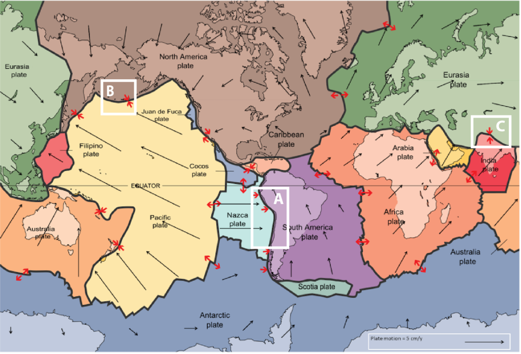
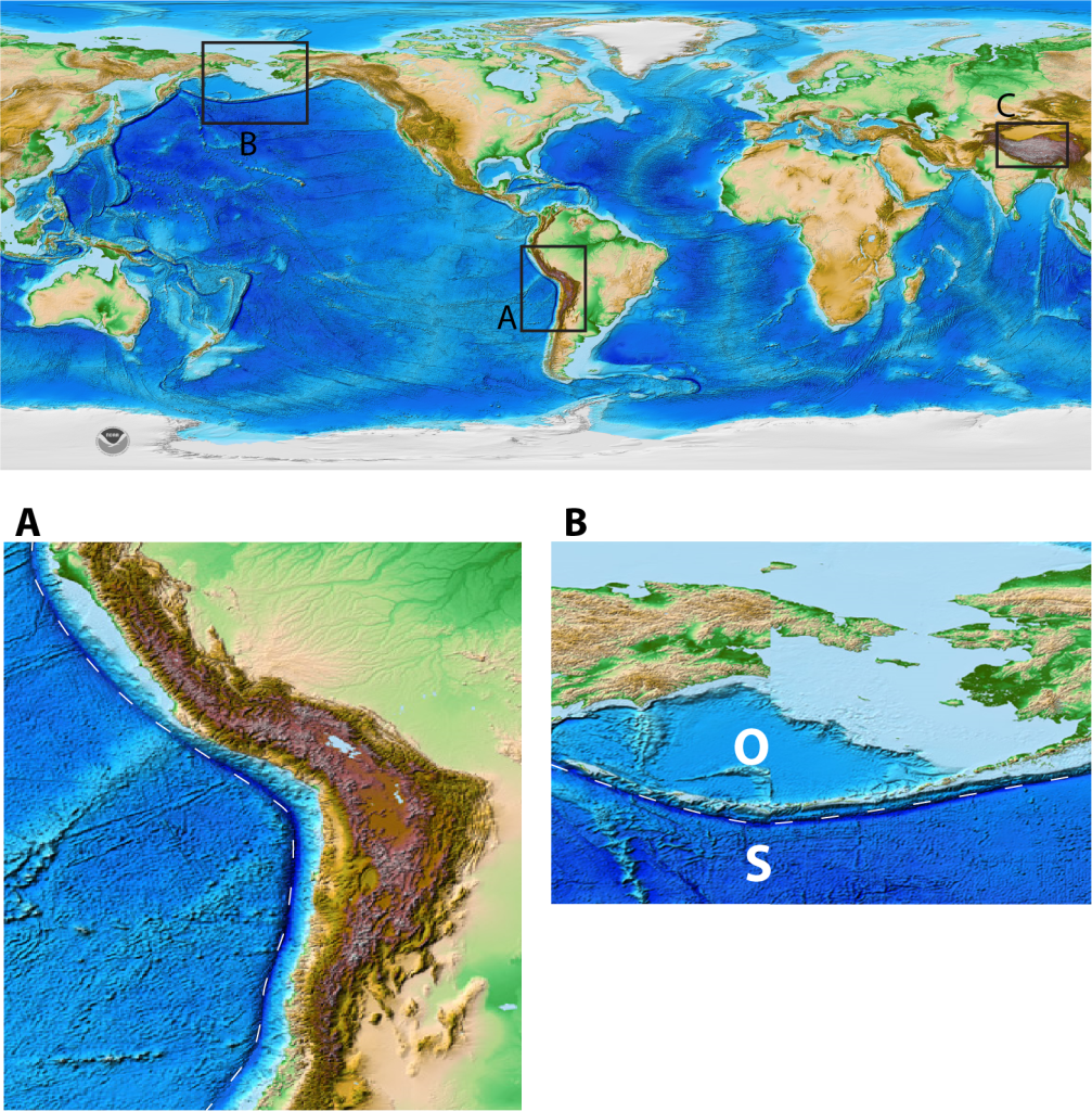
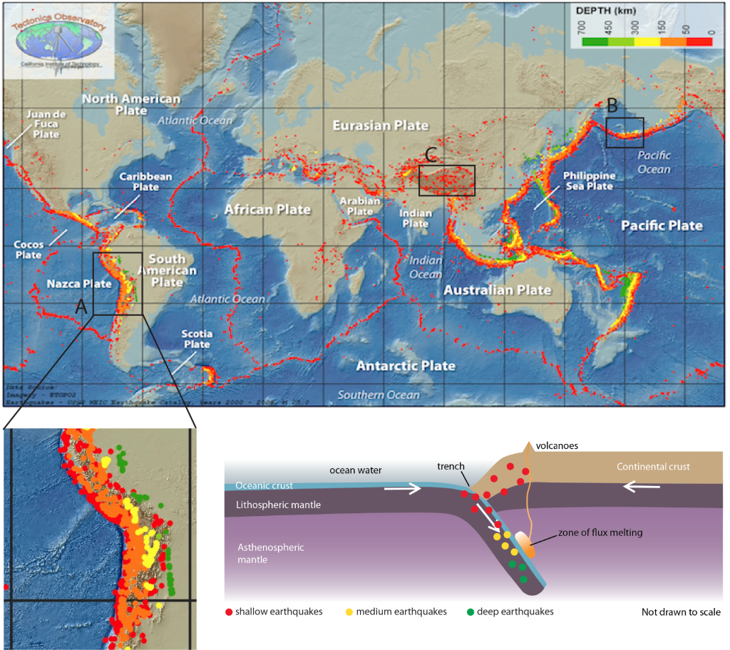
Figure 1A.4.3 below shows two enlarged sections of an elevation map corresponding to Box A: Ocean-continent convergent boundary and Box B: Ocean-ocean convergent boundary from the plate boundary map in Figure 1A.4.1. In both enlarged sections, the location of the plate boundary has been marked as a dashed line and the deep ocean trench area is clearly visible as a dark blue color coinciding with the boundary. In Box A high mountains are visible on the continental/overriding plate. In Box B the subducting oceanic plate has been marked with an “S” and the overriding oceanic plate with an “O”. On the overriding plate of the boundary there is shallower ocean floor (or a chain of volcanic islands) whereas on the subducting plate of the boundary the ocean floor is deeper.
Volcanic Activity
Volcanic activity is very prevalent at subduction zone boundaries. There is water chemically bound within certain minerals in the crust and as the crust subducts and heats up, those chemical bonds are altered allowing water to be released into the overlying asthenospheric mantle. This addition of water lowers the melting point of mantle rocks, causing magma to form. This process is called flux melting. The magma created from this is mafic in composition.
The newly produced mafic magma, which is less dense than the surrounding mantle rocks, rises (straight up, not angled back along the subducting plate) through the mantle and through the overlying crust (oceanic or continental depending on the subduction zone type) where it creates a chain of volcanoes (Figure 1A.4.2). As the mafic magma rise through the overlying crust, its composition can change through various processes including partial melting to become more intermediate and felsic in composition (see the note on partial melting in Section 1A.3).
At ocean-ocean convergent boundaries the chain of volcanoes makes volcanic islands known as an island arc (this is both a volcanic and topographic feature!). At older boundaries, where the islands have been building for longer, these island arcs develop into a chain of relatively large islands (such as Japan or Indonesia). At younger boundaries, they may be small volcanic islands, or even smaller volcanoes that have not grown large enough to be above sea level.
At ocean-continent convergent boundaries, the chain of volcanoes is present on the continental side and sit among the tall mountains present at this boundary type as well. The large compressive forces at convergent boundaries push existing continental rocks into large mountain belts on the continental side of the boundary, as seen in the elevation maps above. The volcanoes are interspersed with non-volcanic mountains.
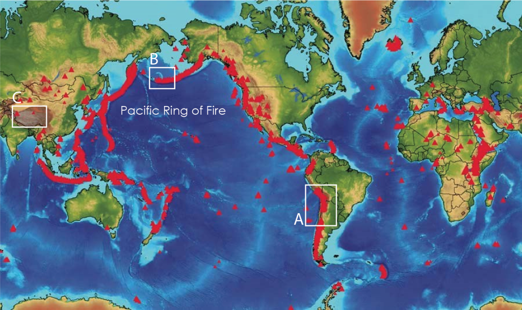
A key identifying factor for volcanoes at all subductions zones is that the volcanoes are always located on the overriding plate side of the boundary (Figure 1A.4.4). This asymmetry in location can be used to help determine which plate is subducting in the case of ocean-ocean convergent boundaries.
Earthquake Activity
Earthquake activity is also very prevalent at subduction zone boundaries. On the map below (Figure 1A.4.5), dots represent earthquakes and are color-coded by depth, with red being shallowest and green being deepest. At subduction zones there is a distinct pattern of earthquake depths with shallowest earthquakes being located on or near the plate boundary, and earthquakes become progressively deeper farther into the overriding plate side. This pattern of earthquakes is called the Wadati-Benioff Zone. Remember that earthquakes happen in brittle lithosphere, not soft asthenosphere, so the only way to get earthquakes deep inside the Earth is to have lithosphere that is deep inside the Earth, and this only happens at subduction zones. Earthquakes occur all along the subducting slab as represented in the schematic diagram on the bottom right of Figure 1A.4.5.
Subduction zones are easily found on earthquake distribution maps by looking for the distinctive banding of shallow through deep earthquakes (which often gets color coded to make a rainbow effect). The direction of the progression from shallow to deep can be used to determine subduction direction.
Seafloor Age
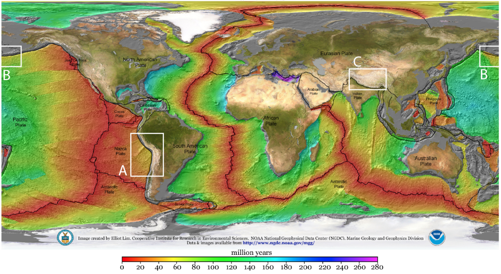
Unlike at divergent boundaries, there is not a specific age of seafloor at subduction zones. Seafloor of any age will subduct provided it is denser than the material on the plate it is converging with. In this sense, the notable age pattern is that the seafloor on the subducting plate gets younger generally moving away from the subduction zone and back towards the divergent boundary where it was created (Figure 1A.4.6).
4.2 Continent-Continent Convergent Boundaries
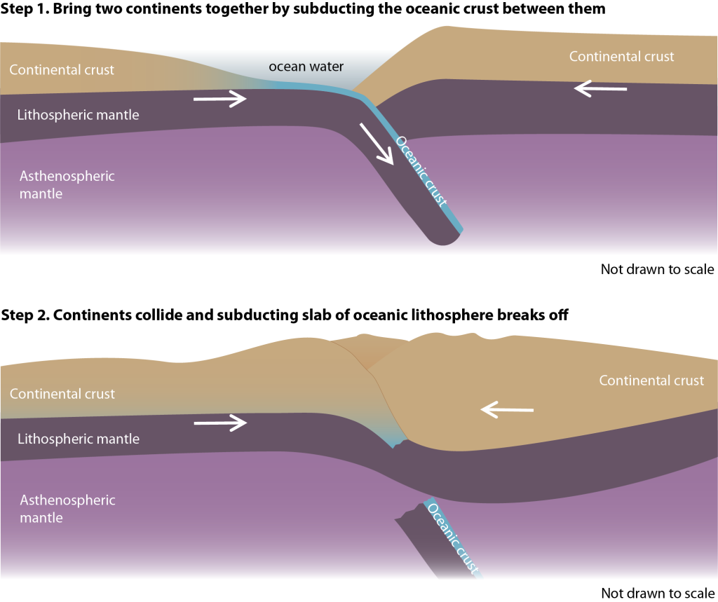
Continent-continent convergent boundaries are also referred to as continent-continent collision zones. These form when two continental plates collide. The lead up to having two continents meet in this way always starts with an ocean-continent subduction zone. Imagine two continents separated by an ocean with an ocean-continent convergent boundary on one side of the ocean. As subduction progresses, the ocean will slowly close bringing the two continents together. At which point, subduction cannot continue as continental crust is too buoyant to subduct. The subducting oceanic portion of the plate will break off from the continental portion and sink into the mantle to be recycled, and the two continental pieces will push against, or collide with, each other (Figure 1A.4.7). That is why these boundaries are often referred to as collision zones.
Topographic Features
With no subduction to be had, the compressing force between the two continental landmasses will push rocks upward into very tall mountains. The tallest mountains on the planet, the Himalayas, are a result of continent-continent collision. This is shown in Box C on the elevation map in Figure 1A.4.3 and in Figure 1A.4.7, above.
Volcanic Activity
As is seen in Box C on the volcano map in Figure 1A.4.4, volcanic activity can be present, particularly earlier on in the timeline of a collision zone when there is still oceanic plate subducting, but it does not need to be present. Partly this is due to a lack of decompression or flux melting like is seen at divergent boundaries and subduction zones, respectively, and partly because the very thick continental crust created means any magma that does form usually cools and solidifies deep inside the crust before it can make its way to the surface and become a volcano.
Earthquake Activity
Earthquake activity at collision zones creates a unique pattern. The compressive forces get transferred over a wide area through the large mountain belts created, which generates a widespread zone of earthquakes that can be quite far away from the plate boundary itself. This wide swath of earthquakes is seen in Box C in Figure 1A.4.5. These earthquakes are mostly shallow, but can reach medium depths, generally correlated with particular geometries of how the plates are interacting. Deep earthquakes however do not occur as even the very thick continental lithosphere in these locations does not extend deep enough to generate earthquakes at depths comparable to the deep earthquakes on subducting lithosphere.
Seafloor Age
Trick section! There is no seafloor at these boundaries (check for yourself in Figure 1A.4.6)! By the time a boundary gets to this stage, the oceanic portion of the plate has been subducted and is gone.
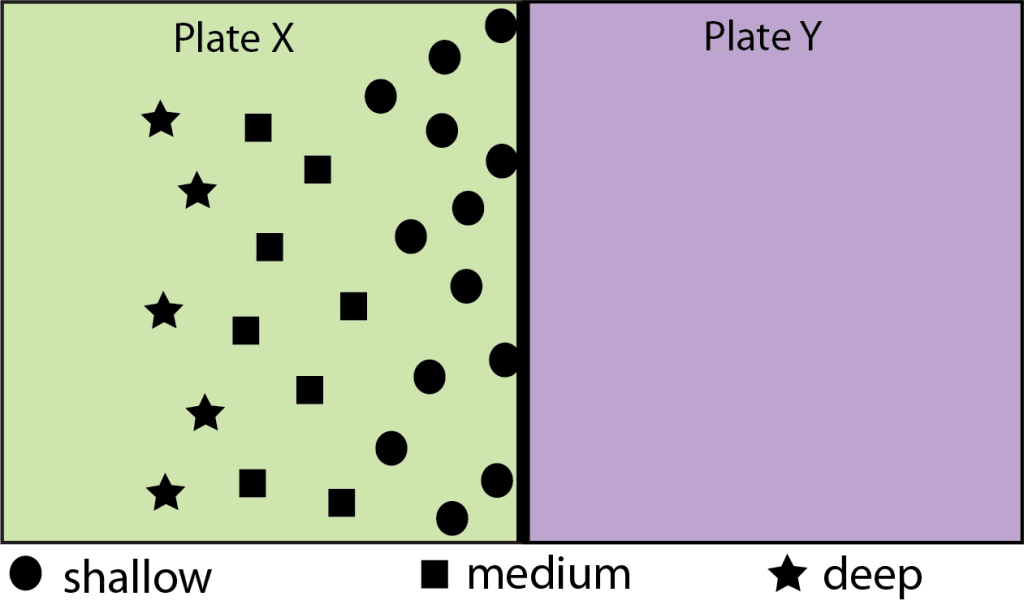
Check Your Understanding: Convergent Boundaries
Use the image below showing the boundary between two oceanic plates, Plate X (green) and Plate Y (purple), to all of the questions. The symbols shown represent earthquakes and a legend is present at the bottom of the image.