6. Assessing Volcanic Risk
Volcanic hazard maps are used to assist in planning responses for future eruptions. They are made by studying historical records of eruptions and the geology of an area surrounding the volcano to determine which areas could be affected by volcanic hazards from a potential eruption. Figure 1C.6.1 below shows the volcanic hazard map for Mt. Rainier, which is located approximately 90 miles north of Mt. St. Helen’s. Mt. Rainier is potentially the most dangerous volcano in the Pacific Northwest due to its proximity to major population centers. It is approximately 25 miles from the southern edge of the Seattle-Tacoma urban area with numerous smaller towns in between.
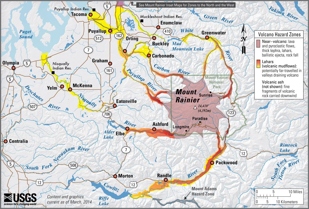
These hazard maps can be used in a variety of ways to aid in emergency preparedness. For example, towns likely to be affected by lahars can educate the population to move to high ground and out of the path of the mudflow during an eruption.
Emergency Preparedness in Vik, Iceland
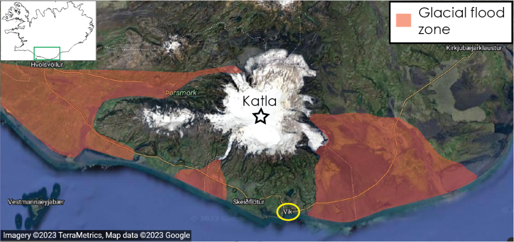
Katla is a major active volcano near the south coast of Iceland that last erupted in 1918. When Katla erupts, it tends to erupt similarly in size to Mt. St. Helen’s making it quite dangerous! While most eruptions associated with mid ocean ridges and volcanic hotspots (the tectonic conditions in Iceland) lead to effusive mafic lava flows, Katla sits underneath the large Mýrdalsjökull glacier. As the ice melts into the rising lava, it adds volatiles which can create explosive conditions (like was seen in the 2010 Eyjafjallajökull eruption). The other major issue associated with these large overlying glacials is the threat of massive glacial outburst floods as the heat from the magma rapidly melts the glacial ice.
The town of Vik is located just south of Katla but is luckily shielded from the glacial outburst floods directly by a mountain between it and Katla. The hazard map showing glacial outburst floods from Katla is shown in Figure 1C.6.2. There is only one highway along the south coast of Iceland that connects Vik to both the east and west. Glacial outburst floods have the potential to cut off the highway on either side of Vik. The problem this creates for Vik is an unknown evacuation direction prior to the occurrence of the floods. It would be dangerous for residents to evacuate not knowing which direction the glacial outburst was headed and potentially get swept off the highway in a massive flood.
Instead of evacuating at the signs of imminent eruption, Vik residents are educated to gather in the emergency center in town. Each house is provided with an evacuation sign where they can indicate the number of people and pets that evacuated from the house. These are put in a prominent place, such as a front window, so that rescue crews know a house was evacuated properly and can focus efforts on houses where people may be trapped.
References
Iceland Department of Civil Protection and Emergency Management (n.d.). Response plan for Katla and Eyjafjallajökull https://www.almannavarnir.is/natturuva/eldgos/vidbunadur/vidbragdsaaetlun-vegna-kotlu-og-eyjafjallajokuls/katla-og-eyjafjallajokull/
