4. Groundwater
4.1 Porosity and Permeability
Groundwater is not as accessible as surface water but as the largest store of non-frozen freshwater in the hydrologic cycle it is a valuable resource for irrigation. It is present almost everywhere on the planet, sometimes at very shallow depths such as in marshlands, and sometimes hundreds of feet deep such as in desert areas like the southwestern U.S. Groundwater is the water present in the open spaces (technically called pore space) in rocks and unconsolidated sediments.
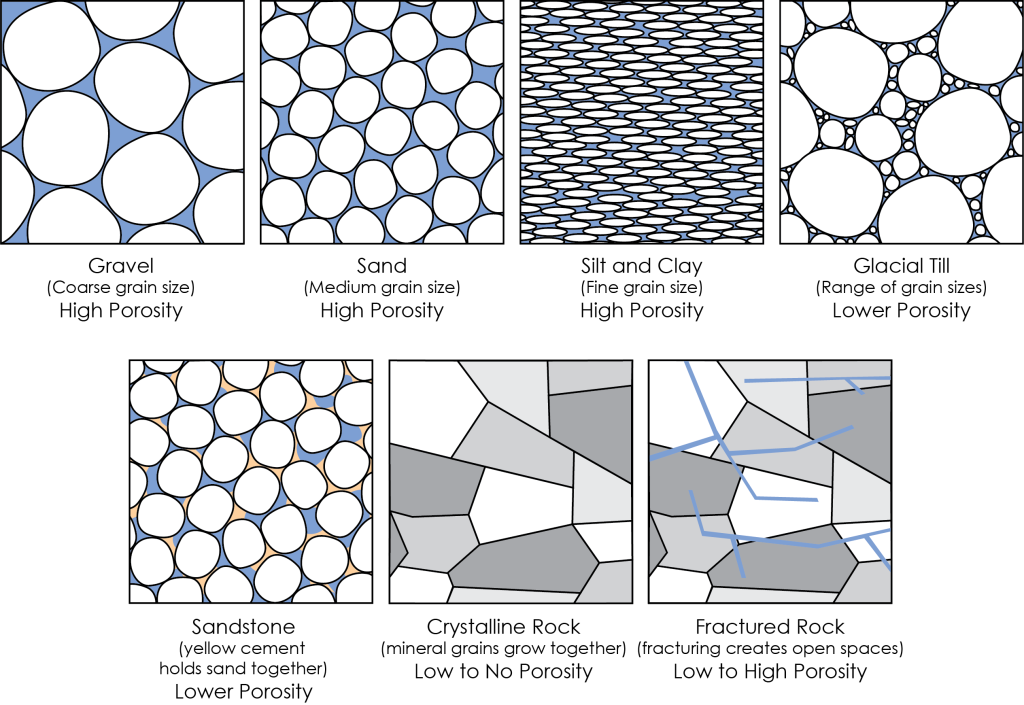
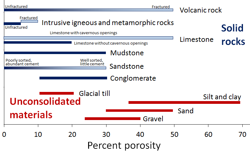
Different rocks and sediments have different amounts of pore space in them. The porosity of a material is a measure of the percentage or amount of pore space compared to the total volume of rock or sediment. Unconsolidated sediments tend to have higher porosity than consolidated ones (ones that have been turned into rocks) because they have no cement filling up the pore space, and most have not been strongly compressed (Figure 2A.4.1 top row). Unconsolidated sediments are classified based on size, with gravel being the coarsest, sand is medium grained, and silts and clays are the finest grained. Unconsolidated sediments can have porosity ranging from 10% – 70%, although are typically in a 10%-30% range (Figure 2A.4.2). Porosity tends to be higher in well-sorted sediments (sediments are all the same size) compared to poorly sorted sediments, where there is a range of smaller particles to fill the spaces made by the larger particles. Glacial till is an example of a poorly sorted sediment, it has grains ranging from large gravels all the way down to small clays. It forms as a result of glacial ice scouring the landscape and has relatively low porosity.
Consolidated sediments (sedimentary rocks like conglomerate, sandstone, and mudstone) and crystalline rocks such as igneous and metamorphic rocks and limestone) have less pore space (if any) than unconsolidated sediments. The cement which binds sediments together to make sedimentary rocks fills in some of the pore space reducing the overall porosity. In crystalline rocks the minerals grow together and may not leave any open space. In all rocks porosity can be created later if the rocks fracture to make open spaces or cracks (Figure 2A.4.1 bottom row). A comparison of rock and sediment porosity is shown in the graph in Figure 2A.4.2.
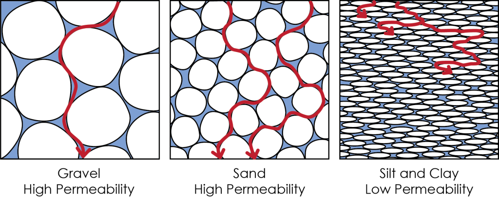
Just because a rock or sediment can hold a lot of water (i.e., has high porosity) does not mean the water can easily flow through the rock. The ability of water to flow through the rock is called permeability. Permeability is a measure of the size and how well connected the pore space in a rock or sediment is and therefore how easily water can move from one pore space to the next.
Smaller pores (not sediment size!) typically mean more twists and turns for the water to have to flow-through which impedes its ability to flow, and if the pore space is not connected at all, then there is not an available path to get through the material. Permeable materials have a greater number of larger, well-connected pores spaces, whereas low permeability (low connectivity and flow) or impermeable (no connectivity or flow) materials have fewer, smaller pores that are poorly (or not) connected.
Think of this like driving through a city where buildings are the sediments/rocks and roads are the pore spaces. The fastest route will be a large multi-lane roadway that cuts straight through the city (this is high permeability) and the slower route will be along small back roads that wind through neighborhoods sometimes hitting dead end streets that require backing up and turning around to find another route (this is low permeability). Note that in both instances, there is still lots of road space, so the porosity is high, it is just the size and connectedness of the roads (the permeability) that has changed!
Gravel is an example of a highly permeable material. It has high porosity, and that porosity is well connected. Clay is an example of a low permeability to impermeable material. While the porosity can be very high in clays (higher even than gravels!), the pore space is small and not well connected so water gets “stuck” in the clay more easily (Figure 2A.4.3).
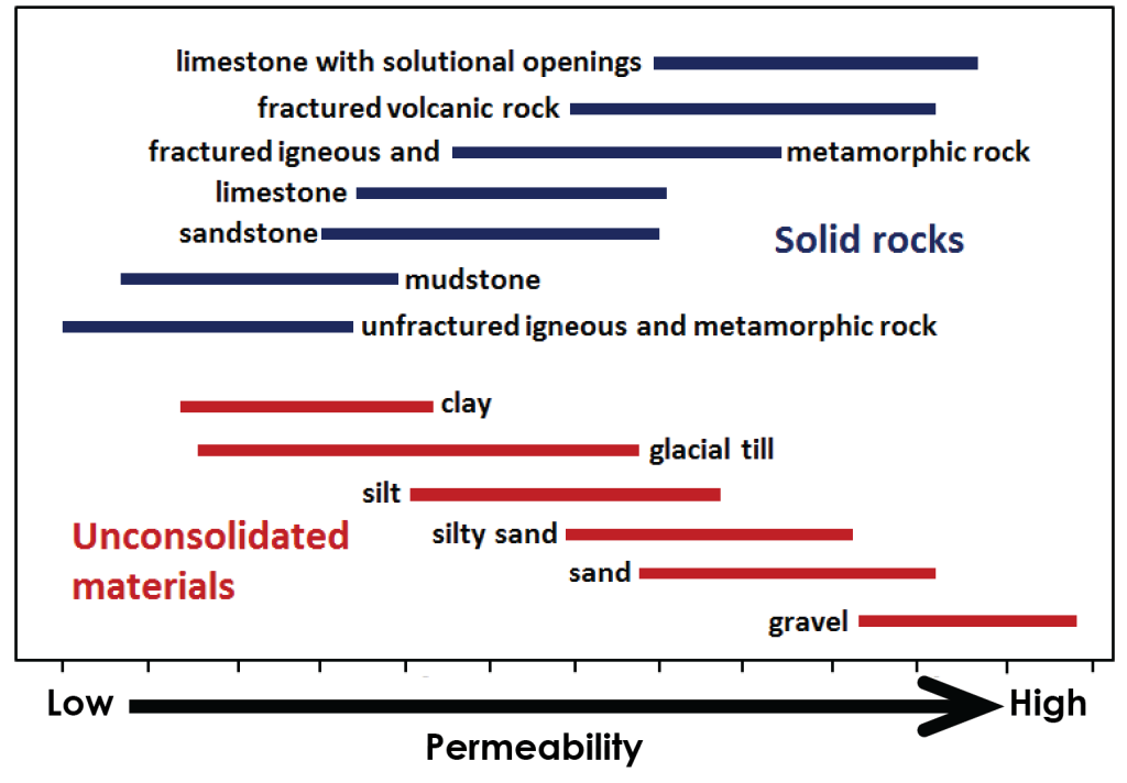
Relative permeabilities are shown in Figure 2A.4.4 below. Permeabilities of rocks are shown in blue and unconsolidated sediments are shown in red. Some sediments like gravel and sand have high porosity (from Figure 2A.4.2) and high permeability. Other sediments like clay have high porosity but very low permeability. Fractured igneous and metamorphic rock has low porosity but can have quite high permeability! This means that the fracturing may not make a lot of open space in these rocks, but the open space it does make is very well connected.
Understanding the porosity and permeability of rocks and sediments in an area is important for getting groundwater out of the ground. The groundwater well needs to be put into a rock layer that has lots of water to begin with (high porosity) but also one where the water will flow easily (high permeability) so it can be pumped out of the ground!
Check your understanding: Porosity and permeability
4.2 Water below the ground: Water Table, Aquifers, and Aquicludes
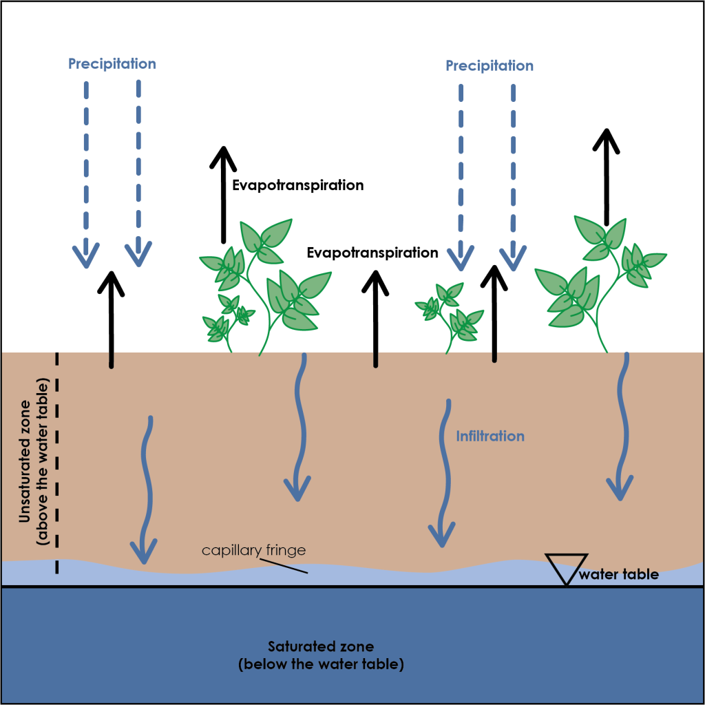
As precipitation lands on the ground, some portion of this water moves down into the subsurface through the process of infiltration. As water travels downwards, it is moving through an area of rock or soil where the pore space is broadly filled with air (dry) although it can be wet to a certain degree but does not stay saturated with water. This is the unsaturated zone. Water continues to move downwards until it reaches rock and sediment where all the pore space is filled with water, or wet. This is the saturated zone. The surface of the saturated zone is called the water table. It is the boundary between the unsaturated and saturated rocks and sediments (Figure 2A.4.5). Note there is a small zone on top of the water table where the rock and sediment are neither fully saturated nor unsaturated. This is the capillary fringe, and it is the transition from the unsaturated to saturated zones. The water table is located at the base of the capillary fringe.
As water works its way below the water table, it will collect and flow differently in different rock and sediment types based on their porosity and permeability. The name for a body of rock or sediment that has high porosity and high permeability is an aquifer. This is the rock or sediment a groundwater well is put into. Unconsolidated materials like gravel and sand, and rocks like sandstone make good aquifers. Other rocks can be good aquifers if they are well fractured.
A body of rock or sediment where the permeability is low, and therefore does not allow easy flow of water is called an aquiclude. Sediments such as clay and glacial till, or poorly fractured crystalline rocks are common aquicludes.
Practice: Combine porosity and permeability knowledge with aquifers and aquicludes
An aquifer where the water table sits within the overall package or layer of rocks that make up the aquifer is called an unconfined aquifer. There is no aquiclude layer between an unconfined aquifer and the ground surface so the water within an unconfined aquifer is at atmospheric pressure. An aquifer where there is an aquiclude layer between it and the ground surface is called a confined aquifer, and the aquiclude separating it from the ground surface is known as the confining layer (Figure 2A.4.6). Water in a confined aquifer can be pressurized. Artesian springs (natural) and artesian wells (manmade) occur where the water is pressurized enough that the water will push its way up to flow out at the ground surface through any available conduit (a fracture in the ground or a well pipe, respectively) without needing to be pumped. There can only be one unconfined aquifer but many confined aquifers at any location under the ground.
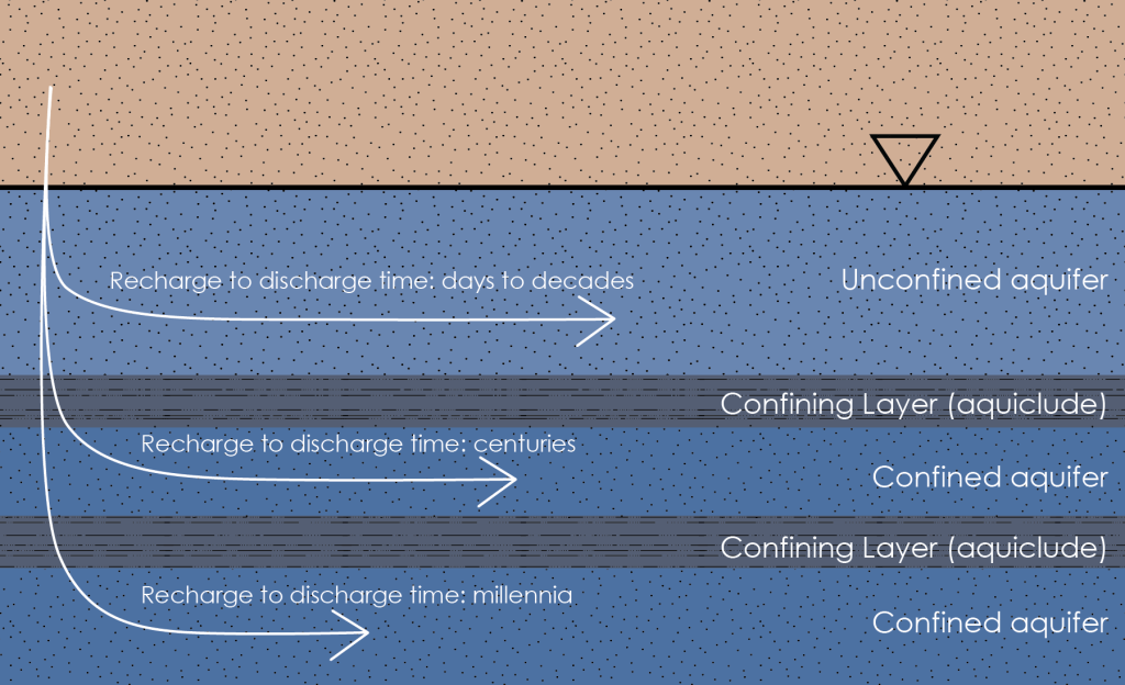
Water infiltrates down to the aquifer where it flows as groundwater, this is called groundwater recharge (the water is recharging or refilling the groundwater). Eventually the water will flow to an area where it will discharge back into surface water or the ocean (the water is discharging or leaving the ground). The flow rate of groundwater is very slow compared to surface water. It ranges from a foot per day at the fast end down to a foot per year or even a foot per decade depending on the permeability of the material it is flowing through. To put this in comparison, an average river flow is in the range of 1-3 feet per second (over 16 miles per day). This means the time that water spends in the ground from recharge to discharge can be very long. Groundwater that flows through the surface unconfined aquifer will spend the least amount of time underground, anywhere from days to decades. Groundwater that travels into deeper confined aquifers can spend much longer underground, anywhere from centuries to millennia before discharging (Figure 2A.4.6).
Check your understanding: Name the layers and processes associated with groundwater
4.3 Water Table Changes
In simple diagrams the water table is often shown as a flat horizontal surface, however in reality the surface of the water table is not flat. It has topography (ups and downs) like the land surface, just with much less difference between the highs and lows. In areas with topographic relief, the water table generally follows the land surface, but tends to come closer to surface in valleys, and intersects the surface where there are streams or lakes. The elevation changes of the groundwater help it to flow. Just like water on Earth’s surface flows from high elevations to low elevations because of the pull of gravity, groundwater flows from high to low water table elevations (Figure 2A.4.7, white dashed arrows).
On the top diagram of Figure 2A.4.7, the recharge area is most of the hillside and the discharge area is the stream in the valley. Recharge areas for groundwater can be quite extensive but discharge areas tend to be in low elevation areas where the water table touches the land surface like lakes and rivers. Groundwater flows from recharge areas to discharge areas.
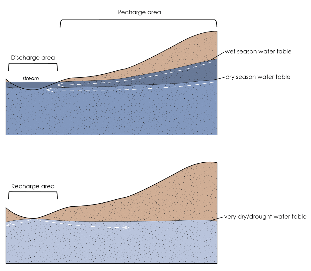
The depth from the land surface to the water table is not constant. The water table will fluctuate over time depending on the amount of recharge it is receiving. In times of high rainfall for example, when there is abundant water for infiltration, the water table will rise as the unconfined aquifer fills with water. During dry times, the water table will fall as it is not being recharged but the water within it is continuing to flow and discharge thereby lowering the water table (Figure 2A.4.7, top). During dry times, the level of a stream or lake will drop as the water table lowers.
If the area has very dry or drought conditions, it is possible for the water table to drop low enough that even a stream or lake, which is typically a discharge area, can become the recharge area (Figure 2A.4.7, bottom). At these locations groundwater is being recharged by any water that might collect in the stream or lake and flowing out into the groundwater because the water table has dropped to below the level of the stream or lake. If the water table continues to drop, the stream or lake could dry up completely.
Knowing how much the water table will fluctuate through the year or over several years is important for making sure a groundwater well is placed at the correct depth. The well needs to be placed deep enough that it will still be in the saturated zone even during very dry conditions, otherwise, the well will run dry!
Check your understanding: Water table elevation changes
