2 Maps and Navigation
Navigating the Ocean

The most accomplished navigators in the history of the world – prior to the invention of global positioning systems driven by satellite location data – were sailors in Polynesia. Much has been written elsewhere of how accomplished these peoples were in navigating the Pacific Ocean during the years 800 B.C to 1300 A.D. They understood an astonishing amount about how to navigate a large, open waterway including but not limited to where ocean currents would take them, how the temperature of the water would change when they were on their intended route, how the stars would move over the course of an evening and through the seasons, that stars useful to navigation would be different in the northern vs southern hemispheres, and how the sun reflecting off the waves and clouds could be used to gain information about location and proximity to land.
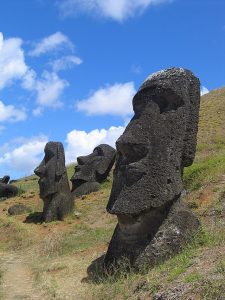
Using these navigation techniques, Polynesian culture spread across the islands of the Pacific, from Fiji in the west, to Hawai’i in the north to Easter Island and New Zealand in the south. Their ability to navigate long distances and reach intended destinations would not be rivaled by European navigators until at least 300 years after the navigators had reached the furthest reaches of their travels.
Polynesian navigation techniques have been the subject of intense anthropological study. From a psychological perspective, their techniques and knowledge represent a combination of navigation techniques that humans are uniquely suited to use. They used some techniques that relied on sensory information gained in the moment. This could be information about ocean temperature or seeing a land mass reflected on the underside of clouds. They also used some navigation techniques that relied on an extensive, abstract map that depended on an understanding of star locations that would occur through the night and would change based on the seasons and whether one was north or south of the equator. Both of these types of techniques represent different ways that people typically use to get around their environment. The Polynesian navigators use these techniques to an unusual degree, but they are the same techniques that you or I might use to navigate around an unfamiliar city.
Navigation
Research Methods
Research associated with navigation has tended to take a neuroscience perspective in recent years. Studies that implant an electrode into the brain of a rat and then have that electrode record the electrical impulses generated by a single cell in the rat’s brain have both been informative to the field and generated public interest in the study of navigation. And while the rat studies are very interesting, we should also be very clear that a human brain and a rat brain are very different things with very different abilities. However, conducting similar studies in humans is very difficult to do.
Generally, neuroscience studies of human navigation rely on humans that need some sort of brain surgery to correct or reduce already occurring neurological symptoms, such as epilepsy. As part of the surgery that helps clear up the problem, an electrode can be inserted that will measure electrical activity in small areas of the brain. However, people that have such electrodes generally have difficulty moving freely about when the electrodes are implanted as the electrode must be wired to large, expensive machinery. Therefore, human studies tend to test the participants as they navigate through a virtual reality environment rather than a real one. This makes comparisons between the human studies and the rat studies difficult and limits the conclusions we can draw from each study as we are not sure if any differences we see in the recordings of rat brains vs. human brains are due to the fact that these are different species, or due to one moving around a real environment and the other a digital one, or something else that we haven’t thought to test.
Cellular Recordings
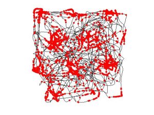
One thing we do know from the single cell recordings of rats is that rats have specific cells that respond to locations. These cells are called place cells and generally begin responding when a rat gets close to a particular location in a room. Interestingly, these cells are not tied to a specific room, but rather to general locations inside all rooms and areas that the rat is generally familiar with. These cells are generally found in the hippocampus of the rat. Rats also have larger groupings of cells that tend to respond together called grid cells that tend to fire in a way that helps the rat map an entire region. The pattern of grid cell firing tends to correspond with an entire space that a rat explores.

Humans are also believed to have something similar to place cells. The evidence is not as good for humans as it is for rats, as we generally do not have control over where the recording electrode goes when it is inserted into a human brain. That electrode is generally there for a medical procedure and researchers are simply collecting whatever day they can using the same equipment. However, it does seem that humans also have cells that respond differentially to locations inside a room. One cell may respond dramatically to being in a corner, while another may respond when the person is at a cardinal point in a square room. Humans also have grid cells which, just as in the rat, help the person understand how to move from one location to another.
Egocentric Navigation: These findings are critical for what is known as egocentric navigation. This simply means navigation from the perspective of the individual person. If someone were to draw a map of where they were when engaging in egocentric navigation, they would draw the map from the perspective of what they see. If you then asked different people to draw the same scene from an egocentric perspective, what they draw will depend on their height and speed moving through that environment. They may indicate that views may become blocked by a tree or another building. They may add details such as being able to see a shortcut if one arrives from one direction but not another. But in this style of navigation, everything is from the perspective of the person moving through the environment.
Wayfinding
To understand this type of navigation, we need to understand something about the process of wayfinding. Wayfinding is much as it sounds, the process of finding our way in an environment. Research on wayfinding has typically focused on environments that tend to be difficult to navigate and create a lot of instances of people becoming lost. Research tends to focus on these environments because the prospect of becoming lost is generally a very negative experience that people would rather avoid. This research typically finds that people generally need three things to navigate through an environment – differentiation, a degree of visual access, and limited spatial complexity.
Differentiation typically refers to the ability to tell one part of an environment from another. Imagine that you were walking on a nature trail that you have never been on before. As you walk on that trail, you may have trouble telling one tree apart from other trees. You would not be able to differentiate the trees and therefore would not be able to gain information about where you are from the trees. This is in part how Polynesian navigators were able to navigate the Pacific Ocean. By using a large set of knowledge including differences in water temperature inside ocean currents, the presence or absence of seabirds, and the presence or absence of vegetation in the water, the navigators were able to differentiate different areas of water and use that information to understand where they were and where they were going when someone without the knowledge and training would see only one large expanse of water.
The next element needed for wayfinding is degree of visual access. This refers to how much of the environment is visible from other points in the environment. In other words, can you see where you want to go from where you currently are? The more visual access that a place has, the easier it is to devise a plan for getting from where you are to where you want to be. Such plans are typically referred to as action plans. Areas that have a lot of open areas with few obstructions blocking views are generally easier to navigate whereas areas with lots of tall buildings, trees, or other obstructions can be much more difficult to get around. An important element of degree of visual access is the concept of transition. Transition refers to being able to perceive the next element in the chain of navigation. Are you able to see how to get from your current location to the next step in navigation?
The final element of wayfinding is spatial complexity. This refers how many different things must be interacted with, avoided, or otherwise dealt with in the process of getting somewhere. Places with more things to deal with in the process of navigating are said to have a higher spatial complexity. A commonly cited example of a location with high spatial complexity is the Seattle Central library. Looking at it from the outside, it is an absolutely beautiful building. Not only that, but many architectural reviews cite the elegant and artistic statements and elements of meaning contained in the relationships between spaces. However, those that typically use the library cite one major problem with the design, which is how complicated it is to get around inside the building. There tend to be many paths that must be navigated to get from the areas with the books to the areas with the services. Patrons also cite the locations of stairways and escalators as a difficult and complex problem that must be solved while navigating.
Allocentric Navigation
People can also navigate using allocentric navigation. This is navigation that takes more of a birds-eye perspective and is what is often represented on maps. It is difficult to know for sure, but it is surmised that rats do not have the ability to use allocentric navigation as they do not have the neural circuitry necessary to project themselves into a place that they currently aren’t at. Humans, however, can do that quite easily. If I asked you to imagine that you were at your favorite ice cream shop, it likely is not difficult for you to imagine that place. It also probably isn’t that difficult for you to imagine how you would get to that place from your current location. You might even think about going there right now, and when you do, you very likely will think about the route to the ice cream shop in a similar way as many mapping and navigation software applications do – as a map that sometimes spins around the direction you are currently facing but sometimes is fixed to cardinal directions like a map.
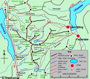
The important elements of allocentric navigation were first proposed as theory by Kevin Lynch in his famous anthropological text “The Image of the City”. This text is a field work report that questions people about the cities of Boston, MA, Jersey City, NJ, and Los Angeles, CA. The people interviewed for the report were asked about important elements within the city and described how they would get between those elements. Lynch theorized that people typically use five elements when describing and drawing locations that are meaningful to them. The first element is landmarks. People tend to choose important or distinctive elements of their environment as places that people can orient towards. The second element that people use to navigate are paths. Here the focus is on how people can move between locations. The third element people navigate with are edges. Edges refer to anything that would block travel. Think about lines on a map that would indicate walls, fences, or other obstacles that would block movement. The fourth element of allocentric navigation is districts. Districts are larger areas on a map that would encompass many different buildings. However, all those buildings have a similar character or purpose. Perhaps your college campus groups all the athletic buildings together. Or maybe there is an area of the city you live in where many shops and restaurants are located. Finally, the last element is nodes. Nodes are areas where human activity is concentrated. These are places you would go to find other people.

These elements on maps were originally theorized by Klein in the Image of the City, but subsequent research has demonstrated that people do typically use these elements in navigation. Research has shown that people have this particular type of map because they are able to use information from maps to navigate to places they didn’t know existed before they looked at a map. If humans could not abstract themselves and only relied on information they could currently see, they could not do this. And while this might seem like a trivial ability, since it is something that we do all the time, it is a remarkable cognitive ability that humans have.
Summary
Finding our way in an environment is an important skill that many creatures possess. Humans have the ability to think about navigation in both an egocentric way – from the perspective of behind their own eyes – and an allocentric way – from the perspective of an overhead view or map. Different neural circuitry lends itself to accomplishing those navigation tasks. Egocentric navigation tends to be facilitated by place cells and grid cells. Allocentric navigation tends to be centered around structures of landmarks, nodes, paths, edges, and districts.
A neuron in the hippocampus that activates when an animal is in a specific location in its environment.
Part of your brain that is responsible for memory and learning. Located near the temporal lobe on the floor of each lateral ventricle.
Cells that help animals navigate their environment by creating an internal coordinate system.
A way of navigating that is based on direction and actions relative to the body, rather than environmental cues.
The process or activity of ascertaining one's position and planning and following a route.
The ability to tell one part of an environment from another
How much of the environment is visible from one particular place in that environment
A detailed plan outlining actions needed to reach one or more goals.
Being able to perceive the next element in the chain of navigation
Mental process that uses external cues such as landmarks, compass directions, or representations on a map to navigate.
An object or feature of a landscape or town that is easily seen and recognized from a distance, especially one that enables someone to establish their location
Elements of a map that indicate how one can travel from one area to another, e.g. streets, sidewalks, subway lines, bus routes, etc.
A line on map that indicates something that blocks travel e.g. fences, building walls, shorelines, cliffs, etc.
Areas on a map that would encompass many different buildings, but all buildings have a similar character or purpose. e.g. "Chinatown" in New York City, shopping districts, apartment districts, single family home neighborhoods, etc.
Area where human activity is concentrated. Places that tend to attract people and can be used to find other people when needed, e.g. plazas, town squares, civic centers, farmers markets, etc.
