10.6 Severe Weather
Severe Weather
Severe weather is classified as “a series of events that can cause destructive or deadly effects on the ground” (NOAA). Severe weather can occur under a variety of situations, but three characteristics are generally needed: a temperature or moisture boundary, moisture, and (in the event of severe, precipitation-based events) instability in the atmosphere.
Thunderstorms
Weather happens every day, but only some days have storms. Storms vary immensely depending on whether they’re warm or cold, coming off the ocean or off a continent, occurring in summer or winter, and many other factors. The effects of storms also vary depending on whether they strike a populated area or a natural landscape. Hurricane Katrina is a good example, since the flooding after the storm severely damaged New Orleans, while a similar storm in an unpopulated area would have done little damage. Thunderstorms are extremely common, with 14 million happening around the world every year; that’s 40,000 per day! Most drop a lot of rain on a small area quickly, but some are severe and highly damaging. They form when ground temperatures are high, ordinarily in the late afternoon or early evening in spring and summer.
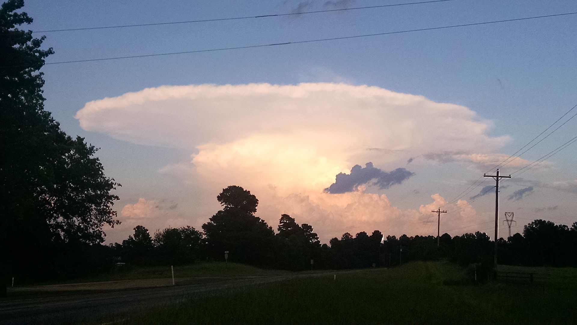
All thunderstorms go through a three-stage life cycle. The first stage is called the cumulus stage, where an air parcel is forced to rise, cool, and condense—occurring at the lower condensation level—to develop into a cumulus cloud. The process of water vapor condensing into liquid water releases large quantities of latent heat, which makes the air within the cloud warmer and unstable, causing the cloud to continue to grow upward like a hot air balloon. These rising air parcels, called updrafts, prevent precipitation from falling from the cloud. But once the precipitation becomes too heavy for the updrafts to hold up, the moisture begins to fall, creating downdrafts within the cloud. The downdrafts also begin to pull cold, dry air from outside the cloud toward the ground in a process called entrainment.
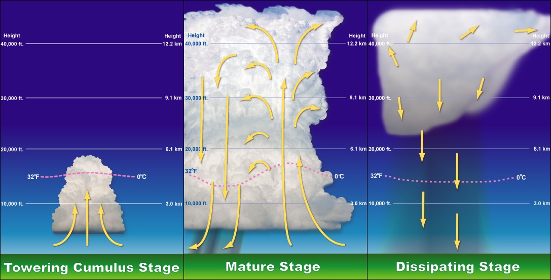
Once the precipitation begins to fall from the cloud, the storm has reached the mature stage. During this stage, updrafts and downdrafts exist side-by-side and the cumulonimbus is called a cell. If the updrafts reach the top of the troposphere, the cumulus cloud will begin to spread outward, creating a defined anvil. At the same time, the downdrafts spread within the cloud and at first widen the cloud but eventually overtake the updrafts. Cool downdrafts form when precipitation and the cool air from entrainment are dragged down to the lower regions of a thunderstorm. It is also during the mature stage that the storm is most intense, producing strong, gusting winds, heavy precipitation, lightning, and possibly small hail.
Once the downdrafts overtake the updrafts, which also prevents the release of latent heat energy, the thunderstorm will begin to weaken into the third and final stage, called the dissipating stage. During this stage, light precipitation and downdrafts become the dominant feature within the cloud as it weakens. In all, only 20% of the moisture within the cloud fell as precipitation, whereas the other 80% evaporates back into the atmosphere.
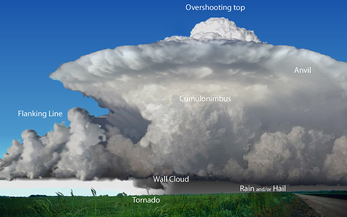
The downdrafts of severe thunderstorms are so intense that, when they hit the ground, it sends warm air from the ground upward into the storm. The warm air gives the convection cells more energy. Rain and hail grow huge before gravity pulls them to Earth. Severe thunderstorms can last for hours and can cause a lot of damage because of high winds, flooding, intense hail, and tornadoes. Thunderstorms can form individually or in squall lines along a cold front. In the United States, squall lines form in spring and early summer in the Midwest, where the maritime tropical (mT) air mass from the Gulf of Mexico meets the continental polar (cP) air mass from Canada. So much energy collects in cumulonimbus clouds that a huge release of electricity, called lightning, may result. The electrical discharge may be between one part of the cloud and another, two clouds, or a cloud and the ground.
Tornadoes
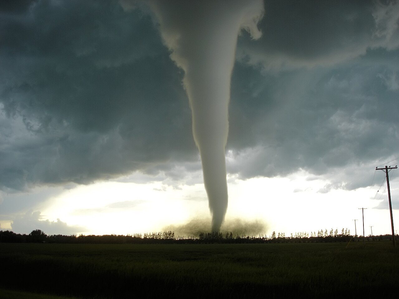
Tornadoes, also called twisters, are fierce products of severe thunderstorms. As air in a thunderstorm rises, the surrounding air races in to fill the gap, forming a funnel. A tornado lasts from a few seconds to several hours. The average wind speed is about 177 kph (110 mph), but some winds are much faster. A tornado travels over the ground at about 45 kph (28 mph) and goes about 25 km (16 miles) before losing energy and disappearing. An individual tornado may strike a small area, but it can destroy everything in its path. Most injuries and deaths from tornadoes are caused by flying debris. In the United States, an average of 90 people are killed by tornadoes each year. The most violent two percent of tornadoes account for 70% of the deaths by tornadoes.
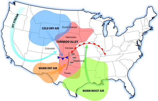
The anatomy and development of tornadoes are not fully understood, but they form from cold fronts, severe thunderstorms, squall lines, supercells, and hurricanes. Geography also plays a crucial role in determining where tornadoes can and cannot form. The majority of thunderstorms in the United States form in the Midwest, which includes an area known as Tornado Alley. This region is where continental polar (cP) air masses from Canada collide with maritime tropical (mT) air from the Gulf of Mexico. This wind shear creates unstable atmospheric conditions and a rotating corkscrew column of air.
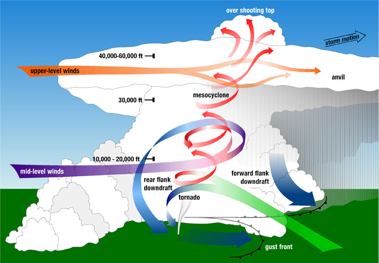
As the ground heats up through the day, updrafts pick up the rotating air into a portion of the thunderstorm to develop what is called a rotating mesocyclone. The updrafts stretch and tighten the now vertical column of air, causing it to rotate faster, much like an ice skater tightens to spin faster. As the rotating updrafts rise, a rotating wall cloud begins to form from the base of a mesocyclone. Sometimes a funnel cloud may begin to descend from the mesocyclone; it may even become a tornado if it reaches the ground.
Although there is an average of 770 tornadoes annually, the number of tornadoes each year varies greatly. In late April 2011, the situation was ripe for the deadliest set of tornadoes in 25 years. In addition to the meeting of cP and mT mentioned above, the jet stream was blowing strongly in from the west. The result was more than 40 tornadoes confirmed each day of the outbreak, with a one-day record of 223 on April 27. The entire region was alerted to the possibility of tornadoes in those late April days. But meteorologists can only predict tornado danger over a very wide region. No one can tell exactly where and when a tornado will touch down. Once a tornado is sighted on radar, its path is predicted and a warning is issued to people in that area. The exact path is unknown because tornado movement is not very predictable.
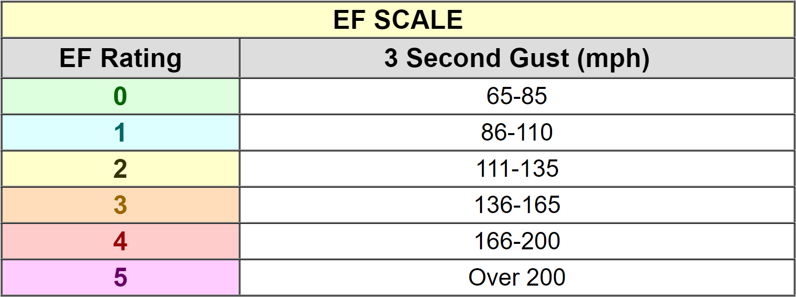
The intensity of tornadoes is measured on the enhanced Fujita scale, which assigns a value based on wind speed and damage. The enhanced Fujita scale, or EF scale, which became operational on February 1, 2007, is used to assign a tornado a rating based on estimated wind speeds and related damage. When tornado-related damage is surveyed, it is compared to a list of damage indicators (DIs) and degrees of damage (DoD), which help estimate better the range of wind speeds the tornado likely produced. From that, a rating (from EF0 to EF5) is assigned. The EF scale was revised from the original Fujita scale to reflect better examinations of tornado damage surveys so as to align wind speeds more closely with associated storm damage. The new scale has to do with how most structures are designed.
Hurricanes
Tropical cyclones are considered some of the most powerful weather systems on the planet because of their size, strength, and potential loss to life and property. Tropical cyclones go by different names depending on geographic location. In North and Central America, they are called hurricanes. In the northwestern portion of the Pacific Ocean near China and Japan, they are called typhoons. Furthermore, in the Indian Ocean and Australia, they are called cyclones.
By any name, they are the most damaging storms on Earth. Hurricanes arise in the tropical latitudes (between 10° and 25° N) in summer and autumn when sea surface temperatures are 28°C (82°F) or higher. The warm seas create a large humid air mass. The warm air rises and forms a low-pressure cell, known as a tropical depression. Thunderstorms materialize around the tropical depression. If the temperature reaches or exceeds 28°C (82°F), the air begins to rotate around the low pressure (counterclockwise in the Northern Hemisphere and clockwise in the Southern Hemisphere). As the air rises, water vapor condenses, releasing energy from latent heat. If wind shear is low, the storm builds into a hurricane within two to three days.
Hurricanes are huge systems with high winds. The exception is the relatively calm eye of the storm, where air rises upward. Rainfall can be as high as 2.5 cm (1 in) per hour, resulting in about 20 billion metric tons of water released daily in a hurricane. The release of latent heat generates enormous amounts of energy, nearly the total annual electrical power consumption of the United States from one storm. Hurricanes can also generate tornadoes.
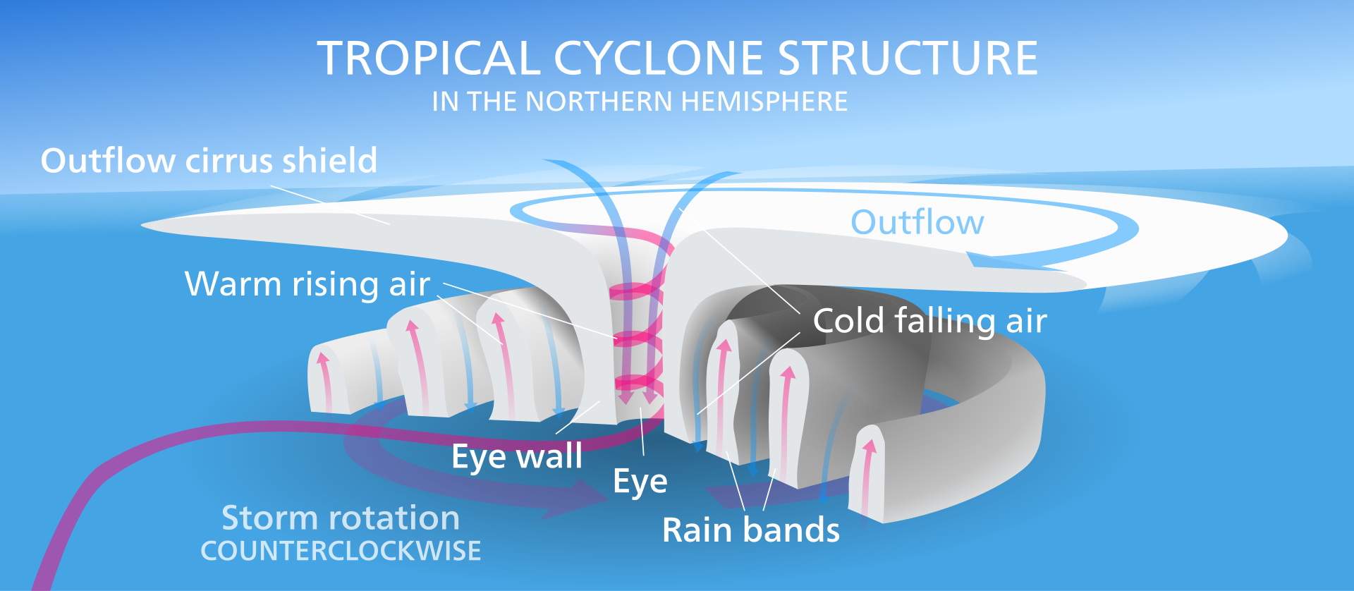
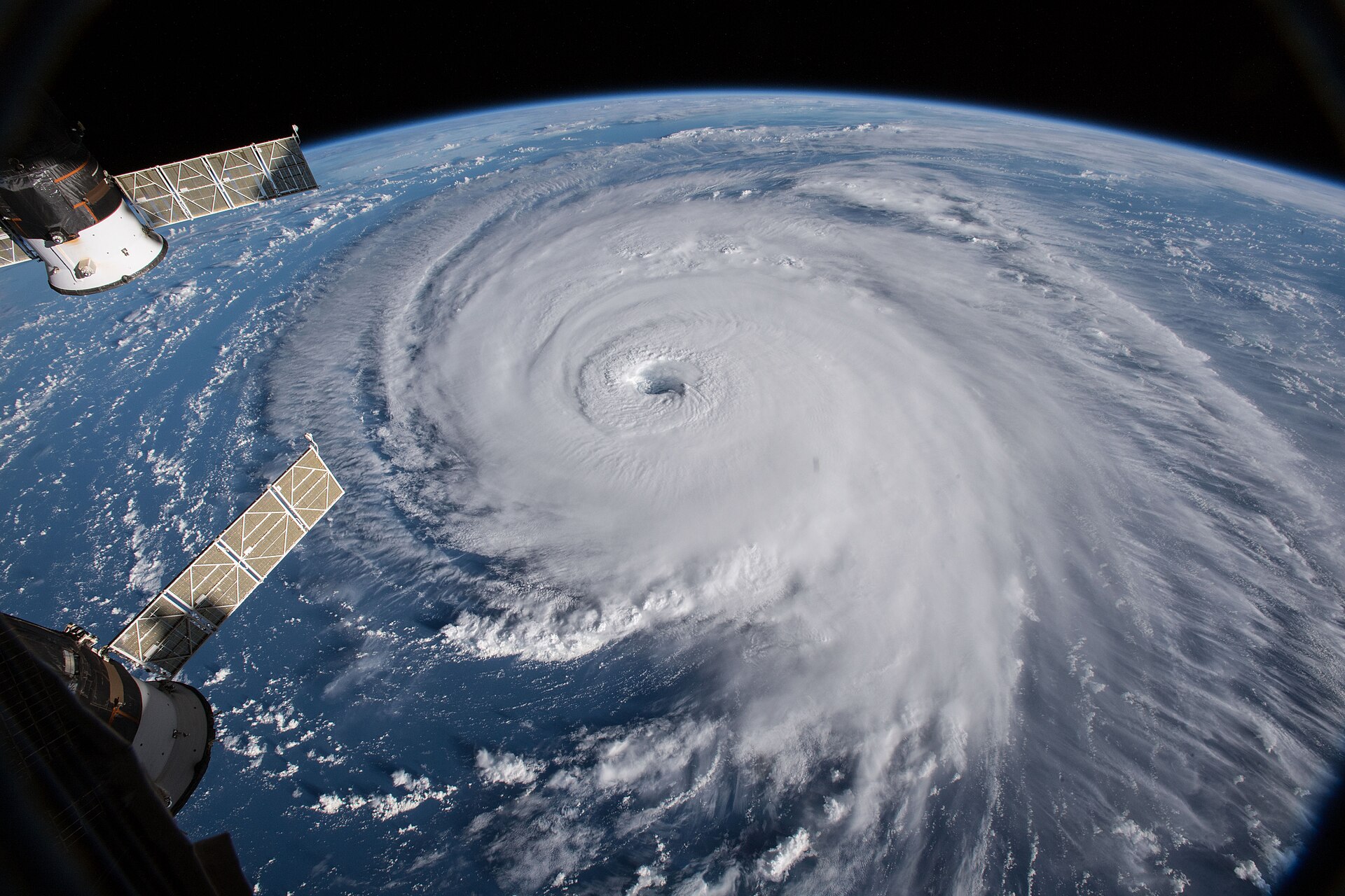
The structure of a hurricane is fairly simple, though the processes involved are quite complex. As a low-pressure disturbance forms, the warm, moist air rushes toward the low pressure in order to rise upward to form towering thunderstorms. Around the low-pressure disturbance is a wall of clouds called an eye wall. Within the eye wall, the wind speeds are greatest, the clouds are the tallest, atmospheric pressure is at its lowest, and precipitation is most intense.
At the center, or heart, of the hurricane is the eye. Within the eye of a hurricane, winds are light, precipitation is minimal, and occasionally the skies above are clear. It is the calm region of the tropical storm, but that is what makes it so dangerous. Many people tend to go outside as the eye moves overhead because they believe the storm is over. But what some don’t realize is that “round two” is coming from behind. Moving away from the eye wall are organized, intense thunderstorms called spiral rain bands, which rotate around and toward the storm’s eye wall.
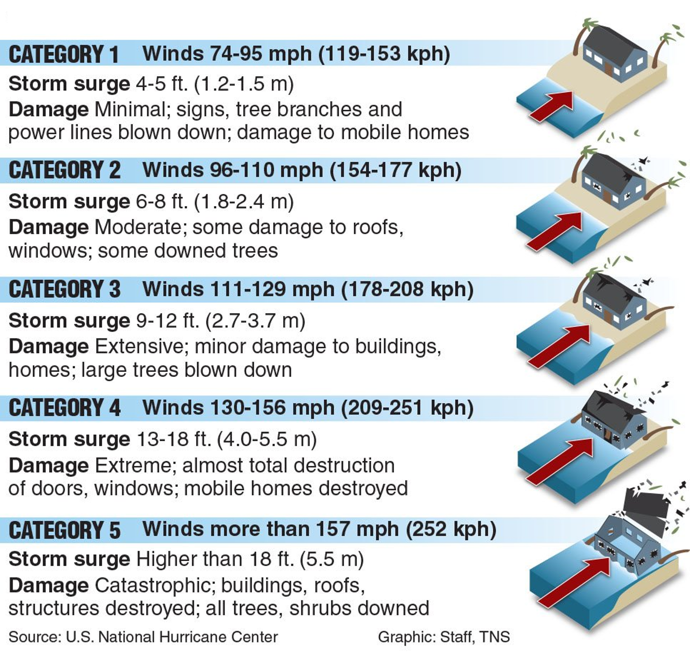
Hurricanes are assigned to categories based on their wind speed and estimated damage. The Saffir-Simpson scale was created to determine the strength and intensity of hurricanes. Just like the Fujita scale, it ranges from 1 to 5, with Category 5 being the strongest. The intensity of a hurricane increases as the atmospheric pressure near the eye decreases and the pressure-gradient force becomes steeper (atmospheric pressure decreases rapidly toward the eye), causing the winds to intensify, resulting in the potential for more damage.
For many years, hurricanes were named based on where they struck land. For example, the Galveston hurricane hit Galveston, Texas, in 1900. In the early 1900s, scientists started naming hurricanes using female names—clearly a sexist action by mostly white, male scientists at the time. But by the 1950s, the National Hurricane Center started naming hurricanes alphabetically, starting with the letter A and using male and female names. If the first year started the letter A with a female name, the following year, the first name would be male. The names are also determined six years in advance so that politics do not get involved with the naming of these deadly storms.
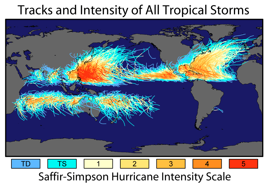
Hurricanes move with the prevailing winds. In the Northern Hemisphere, they originate in the trade winds and move to the west. When they reach the latitude of the westerlies, they switch direction and travel toward the north or northeast. Hurricanes may cover 800 km (500 mi) in one day.
Hurricanes typically last between five and ten days. Over cooler water or land, the hurricane’s latent heat source shut downs and the storm weakens. When a hurricane disintegrates, it is replaced with intense rains and tornadoes. There are about 100 hurricanes around the world each year, plus many smaller tropical storms and tropical depressions. As people develop coastal regions, property damage from storms continues to rise. However, scientists are becoming better at predicting the paths of these storms and fatalities are decreasing.
The National Hurricane Center (NHC) is the division of the United States’ National Oceanic and Atmospheric Administration (NOAA)/National Weather Service (NWS) responsible for tracking and predicting tropical weather systems between the prime meridian and the 140th meridian west poleward to the 30th parallel north in the northeast Pacific Ocean and the 31st parallel north in the northern Atlantic Ocean. Although the NHC is an agency of the United States, the World Meteorological Organization has designated it as the Regional Specialized Meteorological Center for the North Atlantic and eastern Pacific, making it the epicenter for tropical cyclone forecasts and observations occurring in these areas.
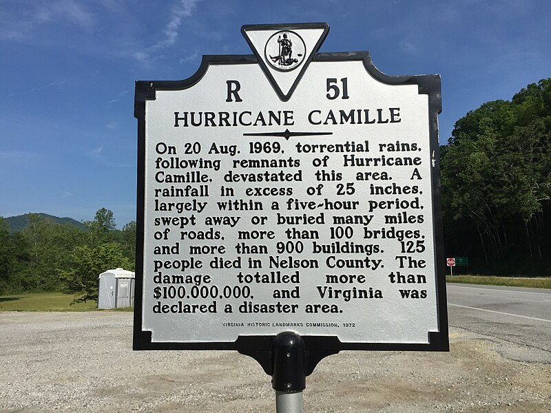
Damage from hurricanes comes from the high winds, rainfall, and storm surge. Storm surge occurs as the storm’s low-pressure center comes onto land, causing the sea level to rise unusually high. A storm surge is often made worse by the hurricane’s high winds blowing seawater across the ocean onto the shoreline. Flooding can be devastating, especially along low-lying coastlines such as the Atlantic and Gulf Coasts. Hurricane Camille in 1969 had a 7.3 m (24 ft) storm surge that traveled 200 km (125 mi) inland.
Winter Storms and Blizzards
Blizzards are dangerous winter storms that are a combination of blowing snow and wind, resulting in very low visibilities. While heavy snowfalls and severe cold often accompany blizzards, they are not required. Sometimes strong winds pick up snow that has already fallen, creating a ground blizzard. Officially, the National Weather Service defines a blizzard as a storm which contains large amounts of snow or blowing snow, with winds in excess of 35 mph and visibilities of less than a quarter-mile for an extended period of time (at least three hours).
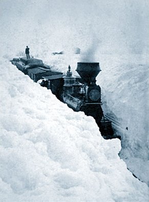
Blizzards happen across the middle latitudes and toward the poles, usually as part of a mid-latitude cyclone. Blizzards are most common in winter, when the jet stream has traveled south and a cold, northern air mass comes into contact with a warmer, semitropical air mass. The very strong winds develop because of the pressure gradient between the low-pressure storm and the higher pressure west of the storm. Snow produced by the storm gets caught in the winds and blows nearly horizontally. Blizzards can also produce sleet or freezing rain.
Blizzards can create life-threatening conditions. Traveling by automobile can become difficult or even impossible due to “whiteout” conditions and drifting snow. Whiteout conditions occur most often with major storms that produce drier, more powdery snow. In this situation, it doesn’t even need to be snowing to produce whiteout conditions, as the snow already on the ground is blown around, reducing the visibility to near zero at times.
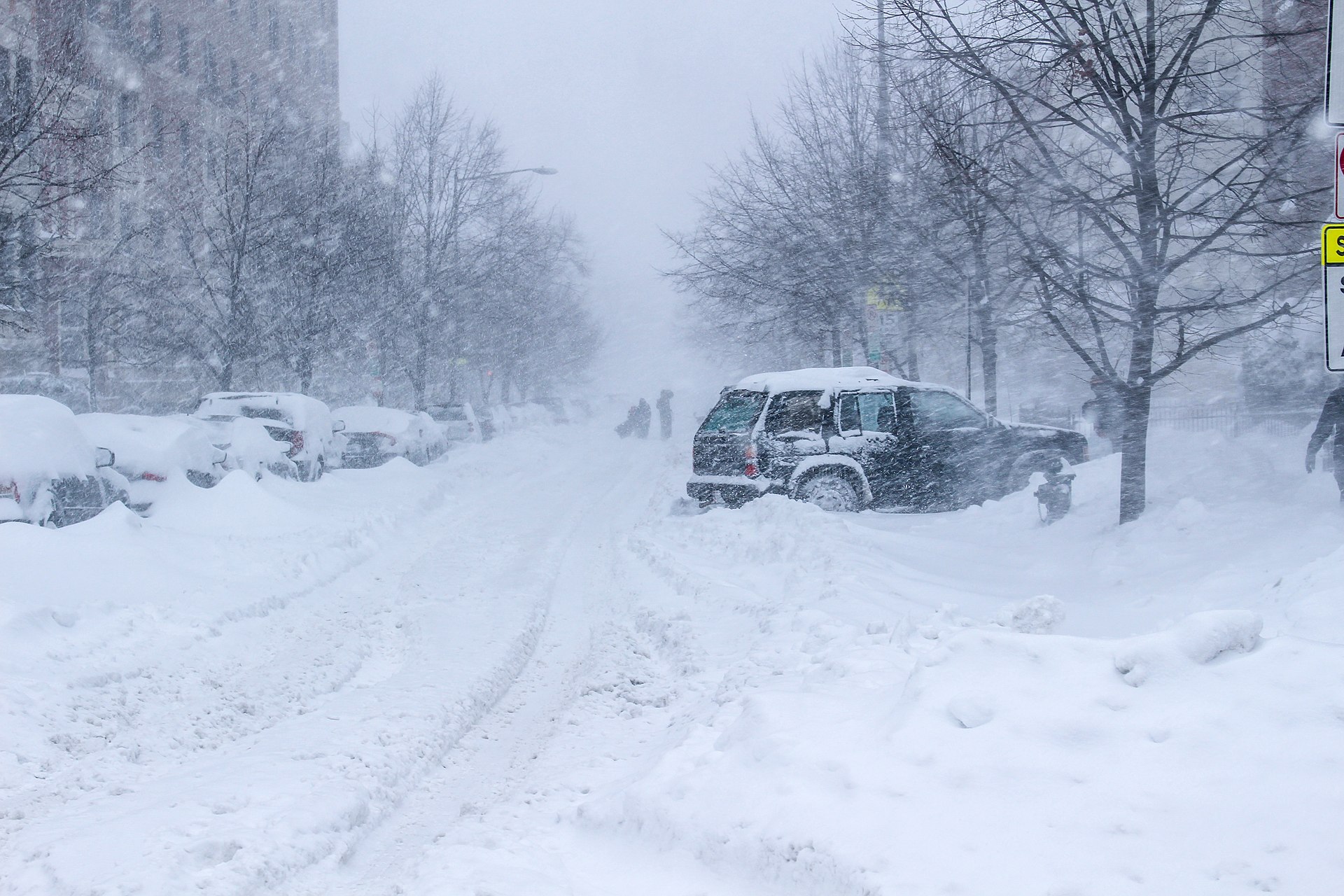
The strong winds and cold temperatures accompanying blizzards can combine to create another danger. The wind chill factor is the amount of cooling one feels due to the combination of wind and temperature. During blizzards, with the combination of cold temperatures and strong winds, very low wind chill values can occur. It is not uncommon in the Midwest to have wind chills below -60°F during blizzard conditions. Blizzards also can cause a variety of other problems. Power outages can occur due to strong winds and heavy snow. Pipes can freeze and regular fuel sources may be cut off.
Heat Waves
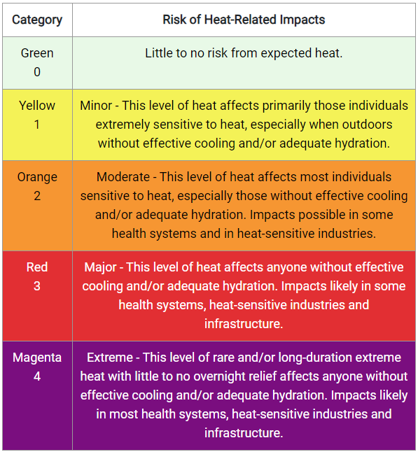
Another potentially deadly weather phenomena is a heat wave. A heat wave is different for different locations; it is a long period of hot weather, at least 86°F (30°C) for at least three days in cooler locations but much more in hotter locations. Heat waves can occur with or without high humidity. They have potential to cover a large area, exposing a high number of people to hazardous heat.
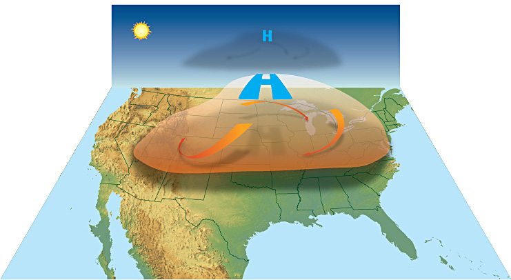
Heat waves form when a high-pressure area in the upper atmosphere strengthens and remains over a region for several days and up to several weeks. This traps heat near the Earth’s surface. It is usually possible to forecast heat waves, thus allowing authorities to issue a warning in advance. Heat waves have become more frequent and more intense over land, affecting almost every area on Earth since the 1950s.
Heat waves have an impact on the economy. They can reduce labor productivity, disrupt agricultural and industrial processes, and damage infrastructure. Severe heat waves have caused catastrophic crop failures and thousands of deaths from hyperthermia. They have increased the risk of wildfires in areas with drought. They can lead to widespread electricity outages because more air conditioning is used.
Heat poses danger to human health and there are a variety of heat related illnesses that can occur. During extremely hot and humid weather, your body’s ability to cool itself is challenged. When the body heats too rapidly to cool itself properly, or when too much fluid or salt is lost through dehydration or sweating, body temperature rises. You or someone you care about may experience a heat-related illness. It is important to know the symptoms of excessive heat exposure and the appropriate responses. The Centers for Disease Control and Prevention (CDC) provides a list of warning signs and symptoms of heat illness, and recommended first aid steps, which can be viewed here.
Take this quiz to check your comprehension of this section.

Attribution:
This section is cloned from Introduction to Earth Science, Second Edition, by Laura Neser, Virginia Tech, published using Pressbooks, under a CC BY-NC.SA 4. (Attribution-NonCommercial-ShareAlike 4.0 International; https://creativecommons.org/licenses/by-nc-sa/4.0/). It may differ from the original.
Media Attributions
- Private: recharge discharge areas
- Section 14.3 quiz
