10.5 Weather Processes
Weather Processes
The energy in our atmosphere creates temperature differences, and these temperature differences cause air rising, sinking, and moving across Earth’s surface. This movement causes wind, storms, rain, and drought. In the following sections, we will explore the processes that control our weather.
Water in the Atmosphere
Humidity is the amount of water vapor in the air in a particular spot. We usually use the term to mean relative humidity, the percentage of water vapor a certain volume of air is holding relative to the maximum amount it can contain. If the humidity today is 80%, it means that the air contains 80% of the total amount of water it can hold at that temperature. If the humidity increases to more than 100%, the excess water condenses and forms precipitation. Since warm air can hold more water vapor than cool air, raising or lowering the temperature can change air’s relative humidity. The temperature at which air becomes saturated with water is called the air’s dew point. This term makes sense, because water condenses from the air as dew if the air cools down overnight and reaches 100% humidity.
Clouds influence weather in a few ways: by preventing solar radiation from reaching the ground, by absorbing warmth that is re-emitted from the ground, and as a source of precipitation. When there are no clouds, there is less insulation. As a result, cloudless days can be extremely hot, and cloudless nights can be very cold. For this reason, cloudy days tend to have a lower range of temperatures than clear days. There are a variety of conditions needed for clouds to form; for instance, clouds form when air reaches its dew point. This can happen in two ways: (1) air temperature stays the same but humidity increases, common in locations that are warm and humid; (2) humidity can remain the same, but temperature decreases. When the air cools enough to reach 100% humidity, water droplets form. Air cools when it comes into contact with a cold surface or when it rises.
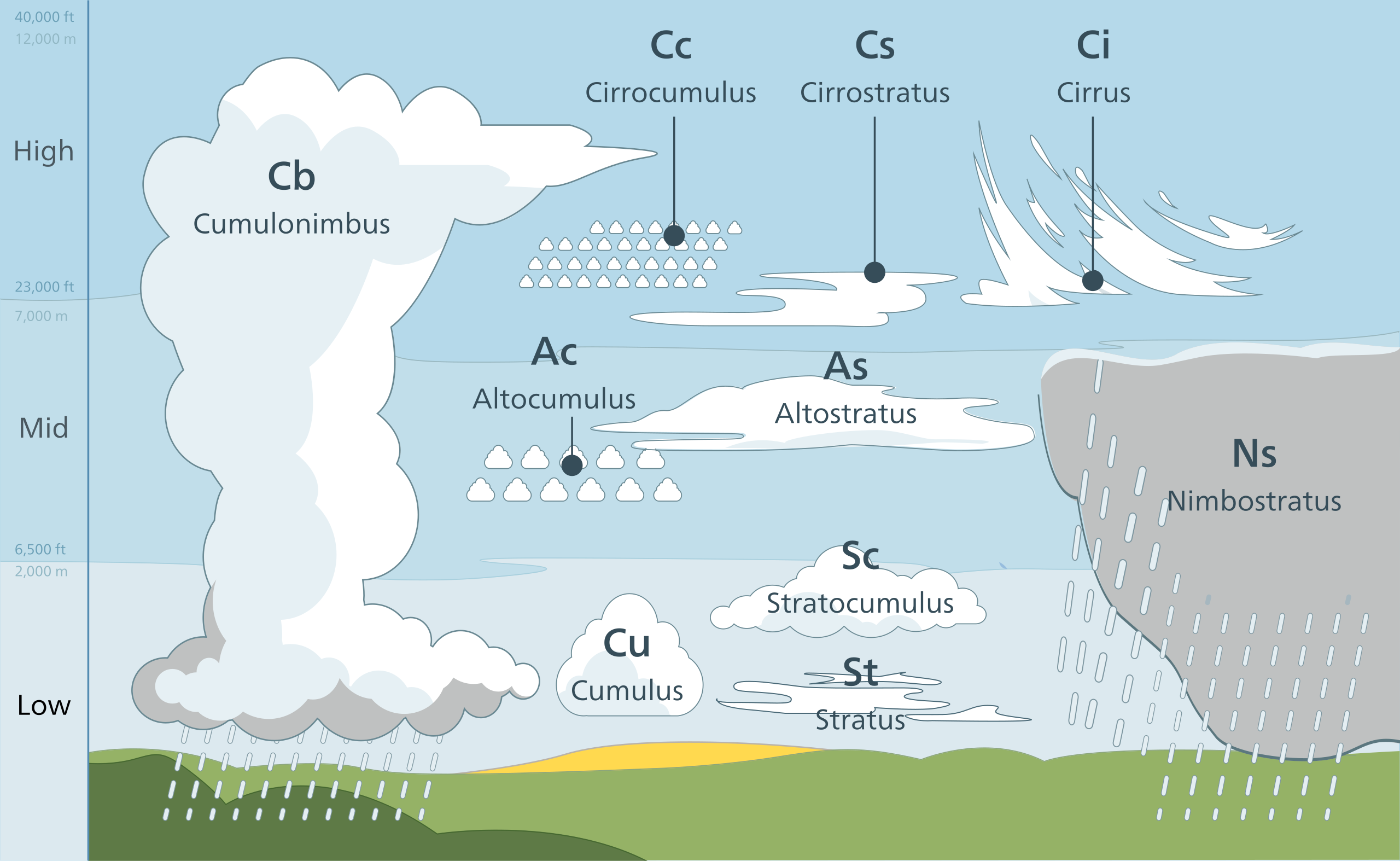
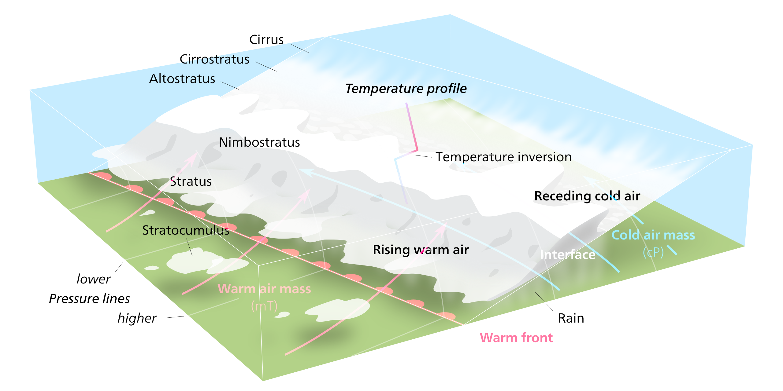
Water vapor is not visible unless it condenses to become a cloud. Water vapor condenses around a nucleus, such as dust, smoke, or a salt crystal. This forms a tiny liquid droplet. Billions of these water droplets together make a cloud. Clouds are classified in several ways. While clouds appear in infinite shapes and sizes, they fall into some basic forms. From his Essay of the Modifications of Clouds (1803), Luke Howard divided clouds into three categories: cirrus, cumulus, and stratus, plus a fourth special type, nimbus. The most common classification used today divides clouds into these four separate cloud groups, which are determined by their altitude and whether precipitation is occurring or not.
High-level clouds, such as cirrus, cirrostratus, and cirrocumulus, form from ice crystals where the air is extremely cold and can hold little water vapor. Middle-level clouds, including altocumulus and altostratus clouds, may be made of water droplets, ice crystals, or both, depending on the air temperatures. Low-level clouds are nearly all water droplets. Stratus, and stratocumulus clouds are common low clouds. A special rain cloud category combines the three forms—cumulo, cirro, and stratus—referred to as a nimbo-form cloud (from nimbus, the Latin word for rain). The vast majority of precipitation occurs from nimbo-form clouds, and therefore these clouds are generally the thickest.

Fog is a cloud located at or near the ground. When humid air near the ground cools below its dew point, fog is formed. The several types of fog each form in a different way. Radiation fog forms at night when skies are clear and the relative humidity is high. As the ground cools, the bottom layer of air cools below its dew point. Tule fog is an extreme form of radiation fog found in some regions. San Francisco, California, is famous for its summertime advection fog. Warm, moist Pacific Ocean air blows over the cold California Current and cools below its dew point. Sea breezes bring the fog onshore. Steam fog appears in autumn when cool air moves over a warm lake. Water evaporates from the lake surface and condenses as it cools, appearing like steam. Warm, humid air travels up a hillside and cools below its dew point to create upslope fog.
Precipitation is an extremely important part of weather. Some precipitation forms in place. The most common precipitation comes from clouds. Rain or snow droplets grow as they ride air currents in a cloud and collect other droplets. They fall when they become heavy enough to escape from the rising air currents that hold them up in the cloud. One million cloud droplets will combine to make only one rain drop. If temperatures are cold, the droplet will hit the ground as a snowflake.
Air Masses
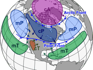
An air mass is a large body of air that covers a relatively wide area and exhibits horizontally uniform properties of moisture and temperature. The location where an air mass receives its characteristics of temperature and humidity is called the source region. Air masses are slowly pushed along by high-level winds, and when an air mass moves over a new region, it shares its temperature and humidity with that region, which means that the temperature and humidity of a particular location depends partly on the characteristics of the air mass above it. Storms arise if the air mass and the region it moves over have different characteristics. For example, when a colder air mass moves over warmer ground, the bottom layer of air is heated. That air rises, forming clouds, rain, and sometimes thunderstorms.
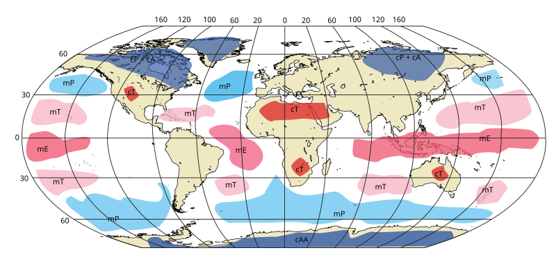
In general, cold air masses tend to flow toward the equator and warm air masses tend to flow toward the poles. This brings heat to cold areas and cools down areas that are warm. It is one of the many processes that act toward balancing out the planet’s temperatures. An air mass is classified by its temperature and moisture and is identified by using a letter code system. The first letter is always lowercase and determines the moisture content within the air mass: m (maritime) is moist, and c (continental) is dry. The second letter is always capital and determines latitude: E (equatorial) is hot, T (tropical) is warm, P (polar) is cold, and A (arctic) is very cold.
Weather Fronts
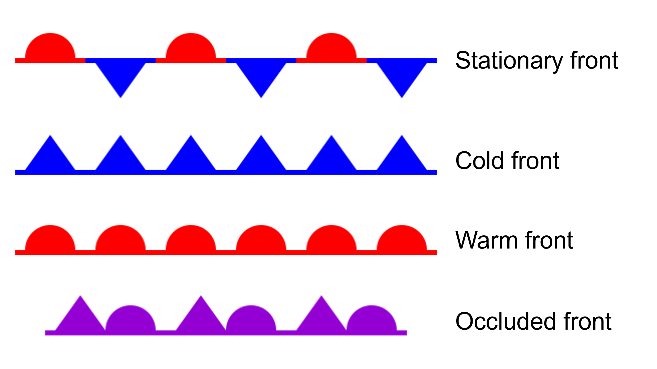
A weather front is a transition zone between two air masses of relatively different densities, temperatures, and moisture. When two air masses come into contact with each other, they do not like to mix well because of their different densities (much like water and oil). Along a weather front, the warmer, less dense air rises over the colder, denser air to form clouds. There are several types of weather fronts: stationary fronts, cold fronts, warm fronts, and occluded fronts.
A stationary front occurs when two contrasting air masses of moisture and temperature connect, but neither of them will ground the other. In many ways, the two air masses are at a stalemate until one of them begins to give ground to the other. Typically, but not always, stationary fronts produce mild but prolonged precipitation.
Cold fronts are zones separating two distinct air masses, of which the colder, denser mass is advancing and replacing the warmer. The colder, denser air pushes under the warm air, forcing the warm, lighter air upward. If the warm air rising is unstable enough, massive thunderstorms are likely to occur. Cumulous and cumulonimbus clouds are common.
Warm fronts mark the boundary between a warm air mass that is replacing a colder air mass. When a warm air mass advances over a cold air mass, the warm air rises over but at a gentler rate than a cold front. Since the warm air does not rise as fast as a cold front, more stratus clouds form and precipitation is not as heavy.
Finally, occluded fronts occur when a cold front overtakes a warm front, causing the warmer air to rise above and meet up with another cold air mass. The air masses, in order from front to back, are cold, warm, and then cold again. The Coriolis effect curves the boundary where the two fronts meet toward the pole. If the air mass that arrives third is colder than either of the first two air masses, that air mass slip beneath them both. This is called a cold occlusion. If the air mass that arrives third is warm, that air mass rides over the other air mass, called a warm occlusion. The weather at an occluded front is especially fierce right at the occlusion. Precipitation and shifting winds are typical.
Physical Controls on Weather and Climate
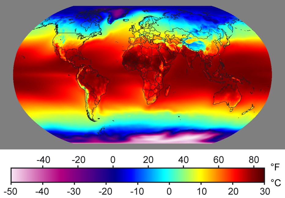
Several controlling factors determine global temperatures. The first and most significant factor controlling Earth’s weather patterns is latitude. Because of the Earth’s shape and the angle at which the Sun hits the planet, temperatures are highest near the equator and decrease toward the poles. In fact, at the equator, more energy is absorbed from the Sun than is radiated back into space. At the poles, more energy is radiated back into space than is absorbed by the Sun. The purpose of weather and ocean currents is to balance out these two extremes.
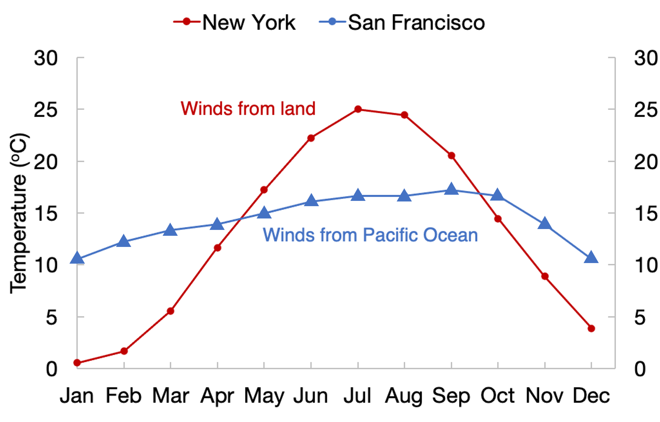
The next impact on temperature is the land-water distribution on the planet. Places near the ocean tend to have milder climates year-round versus regions surrounded by land. This is because land can heat up and cool down faster and with more significant fluctuation than the ocean. The reason is that sunlight must heat a larger volume of area in the ocean since light can pass through water. Water requires five times more energy to rise in heat by one degree Celsius than for landmasses (water has a high specific heat). Thus, the temperatures of regions near large bodies of water change more slowly compared to land.
Ocean currents are also vital controls in transferring heat around the planet. In the Northern Hemisphere, ocean currents rotate clockwise, bringing cold water from the North Pole toward the equator and warm water from the equator toward the North Pole. The opposite occurs in the Southern Hemisphere, where ocean currents rotate counterclockwise. This results in overall cooler temperatures along the west coasts of continents and warmer temperatures along the east coasts.
The last control of temperature is elevation. On average, atmospheric temperature decreases 3.5°F per 1,000 feet rise in elevation (6.4°C/km). This is called the normal lapse rate (a.k.a. temperature lapse rate).
Take this quiz to check your comprehension of this section.
 Attribution:
This section is cloned from Introduction to Earth Science, Second Edition, by Laura Neser, Virginia Tech, published using Pressbooks, under a CC BY-NC.SA 4. (Attribution-NonCommercial-ShareAlike 4.0 International; https://creativecommons.org/licenses/by-nc-sa/4.0/). It may differ from the original.
Media Attributions
- Cloud_types_en.svg
- Private: Permeability © Lindsay Iredale is licensed under a CC BY (Attribution) license
- Figure-1.-The-ocean-is-divided-into-different-zones-based-on-water-depth-and-distance-from-the-shoreline-1
- Warm_front.svg
- Figure 3. Coral reefs are formed by the calcium carbonate skeletons of coral organisms, which are marine invertebrates in the phylum Cnidaria.
- Section 14.2 quiz
